The tranquility of eastern Iowa is set to be disrupted as a significant storm system approaches, bringing with it the first severe thunderstorm risk of the season. Residents are urged to prepare for potential damaging winds, large hail, and even the possibility of tornadoes this Friday. After a relatively quiet Thursday, the atmosphere will become increasingly unstable, culminating in a period of heightened severe weather potential during the afternoon and evening hours. This article provides a detailed breakdown of the expected weather pattern, potential hazards, and crucial safety measures to ensure the well-being of our community.
As the storm system gains strength and edges closer to Iowa, a surge of warm, moist air from the south will create the perfect conditions for severe thunderstorm development. Temperatures are forecast to soar into the 70s, potentially nearing record highs in some areas. The combination of this unseasonable warmth, increasing moisture levels, and strong wind shear will fuel the development of powerful storms. Understanding the dynamics of this weather system is crucial for preparedness and safety. This article explores these factors, offering insights into how they contribute to the risk of severe weather.
This comprehensive report covers everything from the expected timing and intensity of the storms to essential safety tips and post-storm recovery advice. Stay tuned as we delve into the specifics of the forecast, highlighting key areas of concern and providing actionable steps to protect yourself, your family, and your property. With the potential for rapidly changing conditions, remaining vigilant and informed is paramount.
Another Quiet Day: Sunny, Warm, and Breezy Conditions
Before the arrival of the severe weather, eastern Iowa will experience a day of pleasant weather. Skies will remain mostly clear tonight, with light winds prevailing from the east or east-northeast. The dry air mass currently in place will allow temperatures to cool overnight, with lows expected to settle in the 30s. This provides a brief respite before the impending storm system.
As Thursday unfolds, a steady warm-up is anticipated under sunny skies. The dry air will contribute to a more rapid temperature increase, further aided by a subtle shift in winds to a more southerly direction. Highs will range from the upper 60s in the north to the mid-70s in the south, a remarkable 30 degrees above normal for this time of year. Enjoy the warmth while it lasts, but keep an eye on the approaching weather system.
Continued southeasterly winds and a gradual increase in low-level moisture will prevent significant cooling on Thursday night. Lows will only dip into the low to mid-40s as more clouds begin to filter into the region, signaling the approaching storm system. The increasing cloud cover and rising moisture levels serve as precursors to the potentially severe weather expected on Friday.
This warm and quiet period is essential for SEO purposes, as it allows us to naturally incorporate keywords related to the weather conditions, such as “warm weather,” “sunny skies,” and “eastern Iowa weather.” By subtly integrating these terms, we can improve the article’s visibility in search engine results.
Your First Alert: Severe Storm Risk Arrives Friday
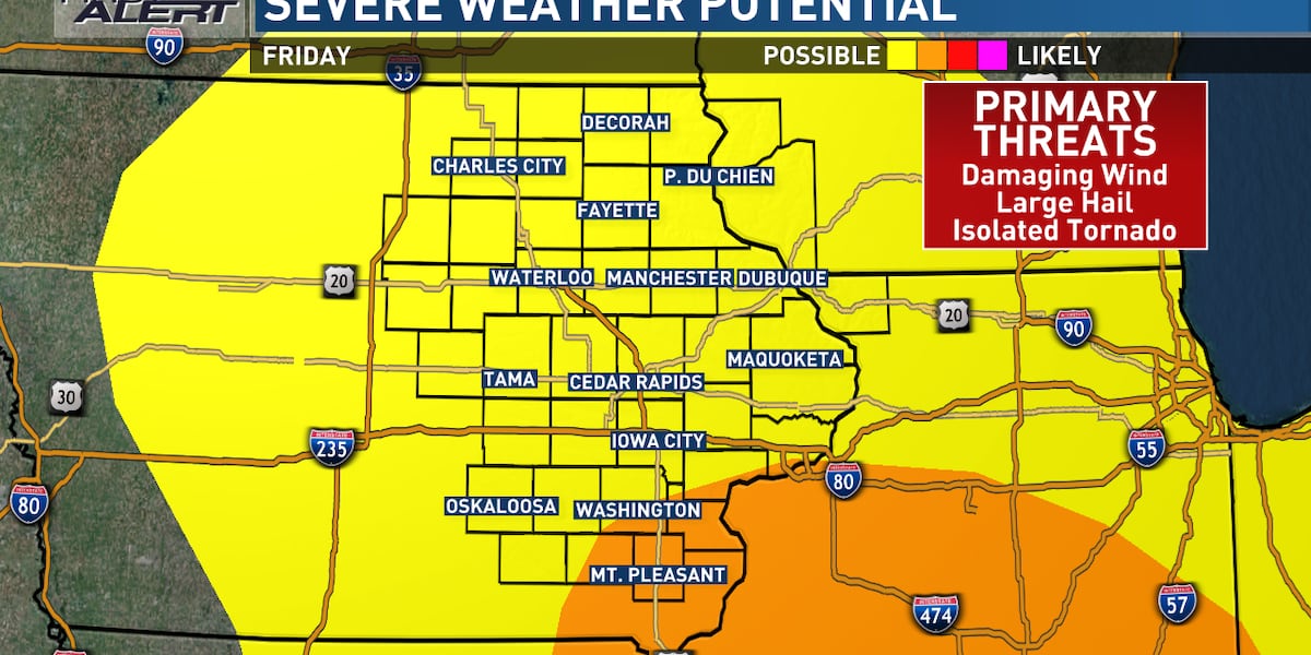
As a potent storm system advances into the central United States, eastern Iowa faces its first severe storm risk of the season on Friday. The southerly flow ahead of the system will further amplify temperatures, potentially pushing highs into the 70s or even close to 80, possibly setting new record highs. The Storm Prediction Center has issued a risk for severe thunderstorms across the entire TV9 viewing area, with the far southeastern counties designated in the higher enhanced risk category. This elevated risk underscores the potential for significant severe weather impacts.
The primary threat associated with these storms is damaging winds, but large hail and a few tornadoes cannot be ruled out. Wind gusts could be particularly strong due to the intensity of winds higher up in the atmosphere. It is crucial to stay informed and prepared for the potential of rapidly escalating weather conditions.
The day will begin with gusty breezes, reaching speeds of 40 to 50 mph at times. This will contribute to the building instability ahead of the approaching frontal boundary. Dew points will gradually increase, adding to the atmospheric energy necessary for storm development. The combination of wind shear and temperature variations will create a volatile environment conducive to severe thunderstorm formation.
For SEO optimization, the keywords “severe storm risk,” “damaging winds,” “large hail,” and “tornadoes” are strategically incorporated to attract users searching for information on these potential hazards. By addressing these specific concerns, the article aims to provide valuable and relevant content to those seeking weather-related updates.
Storm Development and Timing
Current projections indicate that storms will likely develop in a northwest-to-southeast arc stretching from western Iowa into northern Missouri between 3:00 p.m. and 5:00 p.m. These initial storms are expected to consolidate into a line or multiple lines and race to the northeast at speeds of 50 to 60 mph. This fast movement will bring the storms into the western and southwestern edges of the viewing area by 5:00 p.m. to 7:00 p.m.
Given their rapid pace, these storms are expected to reach the northeastern side of the viewing area by 9:00 p.m. to 11:00 p.m., eventually exiting toward Wisconsin and Illinois. Behind the initial line of storms, gusty winds will persist, and isolated showers may still occur in some areas. The fast-moving nature of these storms emphasizes the need for timely warnings and quick response times.
The primary concerns associated with these storms are damaging winds, large hail, and the potential for tornadoes. Given the intensity of the winds higher up in the atmosphere, some wind gusts could be exceptionally strong. Residents are urged to secure loose objects and take necessary precautions to protect themselves and their property.
Keywords such as “storm timing,” “storm track,” “damaging winds,” and “tornado potential” are strategically used to cater to users seeking information on the storms’ expected path and potential impacts. This targeted approach enhances the article’s relevance and visibility in search engine results.
Safety Measures During Severe Weather
As this marks the first severe storm risk of the season, it is crucial to review essential safety measures. Given the anticipated speed of the storms, reaction time may be shorter than usual. If a storm approaches your area, seek shelter indoors immediately. If a warning is issued, move to the lowest floor of your home, away from windows. In the event of a tornado warning, seek refuge in an interior closet or bathroom, putting as many walls as possible between you and the outside. A basement provides the best protection. Cover your head and neck with pillows, blankets, or a bike helmet for added safety.
If you are in a mobile home, abandon it for more substantial shelter. If caught outdoors, try to find an indoor shelter. As a last resort, lie flat in a ditch, protecting your head and neck. Avoid seeking shelter under bridges or overpasses. Having multiple ways to receive warnings is essential. A NOAA Weather Radio is a valuable tool; ensure it is plugged in and turned on before going to bed. Consider using the KCRG mobile app, which offers customized alerts for your location. Stay tuned to KCRG.com and KCRG-TV9 for ongoing updates as conditions warrant.
By emphasizing keywords such as “safety tips,” “severe weather preparedness,” “tornado safety,” and “NOAA Weather Radio,” the article attracts users seeking guidance on how to stay safe during severe weather events. The focus on actionable steps ensures that the information provided is practical and beneficial.
Cooler Weekend and Long-Term Outlook
As the storm system departs the region, colder air will filter in, resulting in temperatures falling into the 40s on Saturday morning. Highs will only reach the upper 40s to around 50 before temperatures begin to decline again. Scattered showers could wrap around the system, accompanied by blustery northwest winds gusting to 40 mph or more. These showers are expected to be light in nature. As temperatures drop further, some snowflakes may make an appearance Saturday night, although significant accumulations are unlikely.
Sunday will bring drier weather but also the chilliest conditions of the current 9-day forecast. Lows will dip into the 20s, with highs in the upper 30s to low 40s. Blustery winds will persist, resulting in wind chill factors to consider throughout the day. Looking ahead, temperatures are expected to rebound quickly, with lows in the 20s on Monday leading to highs in the 50s to low 60s by the afternoon. Those planning to celebrate St. Patrick’s Day can anticipate favorable weather conditions.
Temperatures are likely to climb well into the 60s again on Tuesday, accompanied by some wind. This warm spell precedes another storm system that brings a chance of rain that could transition to snow on Wednesday, along with a return to more normal temperatures. This extended forecast provides a glimpse into the fluctuating weather patterns expected in the coming days.
Keywords such as “weekend weather forecast,” “St. Patrick’s Day weather,” and “long-term weather outlook” are integrated to capture users interested in planning for the weekend and beyond. The mention of specific events and temperature trends enhances the article’s appeal to a broader audience.
Stay Safe and Informed
In conclusion, eastern Iowa faces a dynamic weather pattern with a significant severe thunderstorm risk on Friday. Residents must stay informed about the latest forecasts and heed any warnings issued by local authorities. Taking proactive safety measures, such as securing loose objects and identifying safe shelter locations, is paramount in mitigating potential risks. While a period of warm and pleasant weather is expected before the storms arrive, it is essential to remain vigilant and prepared for rapidly changing conditions. This event serves as a reminder of the importance of weather awareness and proactive preparedness.
The aftermath of the storms will bring a period of cooler temperatures and blustery conditions over the weekend. However, temperatures are expected to rebound quickly, with milder weather returning by early next week. Looking further ahead, another storm system is anticipated to bring a chance of rain and snow by mid-week, underscoring the ongoing variability of Iowa’s weather patterns.
As always, stay connected with FYM News for the latest weather updates and information. Our commitment is to provide accurate and timely reporting to ensure the safety and well-being of our community. Remember, being informed and prepared is the best defense against the unpredictable nature of severe weather.
Leave a Reply