The Tampa Bay area faced a tense situation on Sunday as a tornado warning was issued for Pasco, Polk, and Hillsborough counties. The warning, which urged residents to seek shelter, was part of a broader severe weather threat impacting the region. This article provides a detailed overview of the events as they unfolded, offering insights into the warnings, potential hazards, and safety measures advised by local meteorologists.
Understanding the nature of these warnings and how to respond is crucial for ensuring personal safety and minimizing potential damage. We will explore the timeline of events, the specific areas affected, and the meteorological factors contributing to the severe weather. Additionally, we’ll delve into the guidance provided by FOX 13 meteorologists, helping you stay informed and prepared for future weather events.
Tornado Warnings and Expirations
The afternoon began with tornado warnings issued for Pinellas, Hernando, and Citrus counties, which later expired. However, the situation intensified as a new tornado warning was issued at 7:35 p.m. for Pasco, Polk, and Hillsborough counties. This warning was set to expire at 8:00 p.m., keeping residents on high alert during that period. A tornado watch remained in effect for the wider Tampa Bay region, indicating the potential for further tornado development.
These rapid changes in warnings highlight the dynamic nature of severe weather and the importance of staying updated with the latest information. Meteorologists like Paul Dellegatto emphasized the possibility of hail in some areas, adding another layer of concern for residents.
Damaging Winds and Tornado Potential
According to FOX 13 Meteorologist Paul Dellegatto, the storms moving through the Tampa Bay region had the potential to bring damaging wind gusts and even brief tornadoes. This assessment underscored the need for residents to take all warnings seriously and be prepared to seek shelter if necessary. The combination of high winds and potential tornado activity posed a significant threat to property and personal safety.
The meteorologists stressed the importance of having multiple ways to receive weather warnings, ensuring that individuals could stay informed regardless of their location or activity. This proactive approach to weather awareness is vital in mitigating the risks associated with severe weather events.
Tornado Watch vs. Tornado Warning
A key distinction was made between a tornado watch and a tornado warning. A tornado warning indicates that a tornado has been sighted or detected by radar, necessitating immediate action. In contrast, a tornado watch means that conditions are favorable for tornadoes to develop in the area. Understanding the difference between these two alerts is crucial for determining the appropriate response.
The article reiterated the recommended safety measures for a tornado warning, advising people to seek shelter in a closet or bathroom, away from windows, doors, and outside walls. These guidelines are designed to protect individuals from flying debris and potential structural damage.
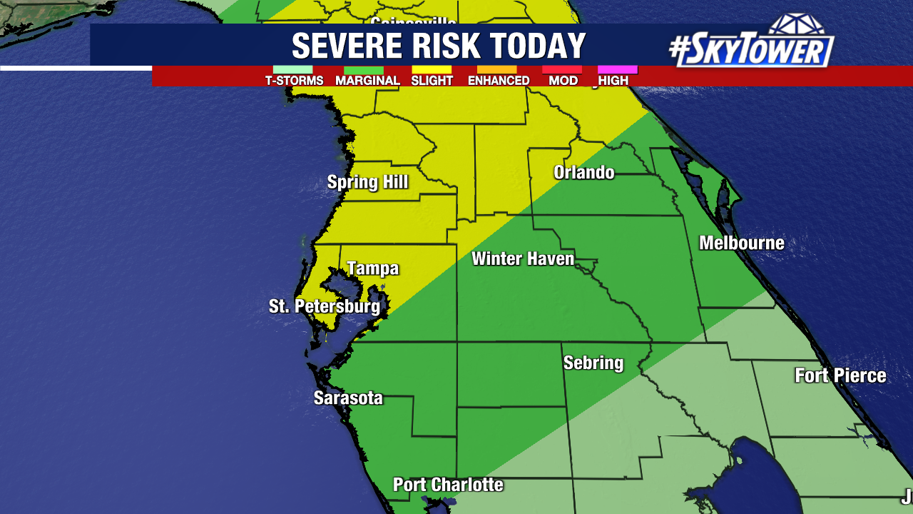
Wider Weather Impact
FOX 13 Meteorologist Valerie Mills noted that the weather system impacting Tampa Bay was part of a larger pattern extending up the east coast. This broader perspective highlights the interconnectedness of weather systems and the widespread nature of the severe weather threat. The image provided showed the extent of the severe weather threat across the eastern United States.
Understanding the regional context of the weather event can help residents appreciate the scale of the situation and the importance of heeding warnings and advisories. It also underscores the role of meteorologists in tracking and predicting these large-scale weather patterns.
Tampa Bay Specifics
Focusing on the Tampa Bay region, the article provided a local perspective on the expected impacts. The most significant effects were anticipated to occur on Sunday evening. As of Sunday morning, wind speeds were expected to range from 10 to 20 MPH as the storms moved in. Temperatures were forecast to remain comfortable, with highs in the low 80s.
While the threat of a tornado and flooding was deemed low, the likelihood of high winds and heavy rain was considered more probable. This nuanced forecast allowed residents to prepare for the most likely scenarios while remaining vigilant for any potential escalation of the weather situation.
Staying Informed
The article emphasized the importance of staying connected with FOX 13 Tampa for the latest updates. It provided links to various resources, including the FOX 13 app for smart TVs, the FOX Local mobile app, and options for receiving breaking news alerts. These resources ensure that residents have access to timely and accurate information, empowering them to make informed decisions about their safety.
In an era of rapidly evolving weather patterns and increasing climate concerns, access to reliable weather information is more critical than ever. By providing these resources, FOX 13 Tampa plays a vital role in keeping the community informed and prepared.
Key Takeaways
In summary, the tornado warning issued for Pasco, Polk, and Hillsborough counties on Sunday underscores the importance of staying informed and prepared during severe weather events. The distinction between a tornado watch and a tornado warning is critical for understanding the level of immediate threat. Residents are advised to have multiple ways to receive weather alerts and to follow safety guidelines if a warning is issued.
The severe weather threat, which extended up the east coast, highlights the interconnectedness of regional weather patterns. By staying connected with local news sources like FOX 13 Tampa, residents can access the latest information and make informed decisions to protect themselves and their property. The events of Sunday serve as a reminder of the power of nature and the importance of preparedness in mitigating potential risks.
Leave a Reply