A powerful storm system tore through the Midwest on March 19, 2025, spawning tornadoes in Illinois and triggering severe thunderstorm watches across several states. The National Weather Service issued tornado warnings for areas south of Chicago, placing millions on high alert. This event, while not as catastrophic as previous outbreaks, still posed a significant threat to communities throughout the region.
From Chicago to Indianapolis, and Louisville to parts of Kentucky, residents braced for damaging winds, hail, and potential tornadoes. This article will break down the key events of the storm, highlight the areas most affected, and provide essential safety information to help you stay prepared during severe weather events. Stay tuned to FYM News for the latest updates and expert analysis.
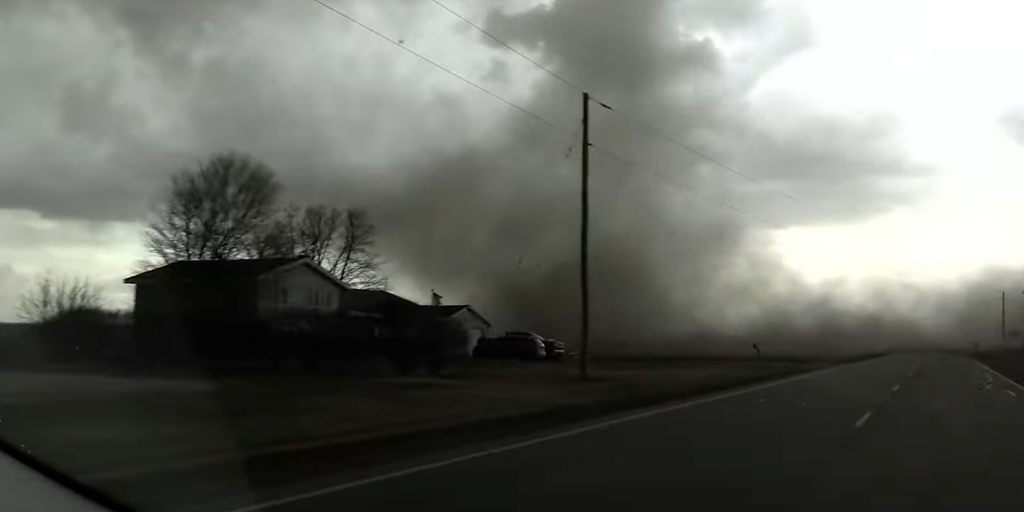
Tornadoes Spotted in Illinois
Several tornadoes were reported in Illinois on Wednesday, March 19th, as a severe storm system moved across the Midwest. FOX Weather storm chasers Brandon Copic and Corey Gerken captured live footage of the storm, highlighting the intensity of the weather event. The storm prompted nearly a dozen tornado warnings, particularly impacting communities south of Chicago.
While the tornadoes caused concern, initial reports indicated no significant damage or injuries. The focus then shifted to the broader severe weather threat encompassing a large portion of the Midwest. Approximately 50 million people found themselves in an increased risk zone for severe weather, underscoring the widespread nature of the storm system.
The FOX Forecast Center noted indicators like “dirty rain” and “gustnadoes,” suggesting that the event wouldn’t be record-breaking. However, numerous reports of severe weather poured in, emphasizing the need for continued vigilance. Gustnadoes, caused by strong winds racing ahead of thunderstorm downdrafts, can inflict damage equivalent to EF-0 or EF-1 tornadoes.
Exclusive Storm Tracker Brandon Copic of FOX Weather witnessed one such vortex near Stanford, Illinois, as a line of tornado-warned storms swept across the state. Areas around Hammond, Indiana, and Chicago Heights were also placed under a tornado warning due to radar-indicated tornadoes.
Severe Weather Watches and Warnings Across the Midwest
Tornado Watches remained in effect for northern and central Illinois, along with western Indiana, throughout Wednesday night. A separate Tornado Watch covered parts of southern Illinois, southern Indiana, and western and central Kentucky until 11 p.m. CDT. Cities including Louisville and Lexington, Kentucky, were included in the watch.
Simultaneously, a Severe Thunderstorm Watch was issued for areas further north and east, highlighting the multifaceted nature of the weather threat. These watches indicate conditions are favorable for the development of severe thunderstorms and tornadoes, prompting residents to stay informed and prepared.
The National Weather Service and local weather outlets urged people in the watch areas to monitor weather updates closely, have a plan in place in case a warning is issued, and know where to seek shelter if necessary. Staying connected with trusted weather sources is crucial during severe weather events.
Blizzard Conditions and Hail Accumulation
The initial wave of extreme weather on Wednesday hit portions of Nebraska and Iowa, bringing a mix of snow and blizzard conditions. These conditions led to power outages across Nebraska, Kansas, and Iowa as strong winds persisted into the night. A 74 mph wind gust was recorded in Lincoln, underscoring the severity of the storm.
Hail accumulation along Interstate 72 in Illinois created hazardous driving conditions, with multiple crashes reported as ice covered the roadways. National Weather Service offices across Illinois received reports of hail ranging from pea-size to quarter-size, blanketing grassy areas. The combination of snow, ice, and hail created widespread travel disruptions and safety concerns.
These conditions highlight the diverse range of weather impacts associated with this powerful storm system. From tornadoes and severe thunderstorms to blizzards and hail, the Midwest faced a barrage of challenging weather conditions. Understanding these different hazards is essential for residents to prepare and respond effectively.
Severe Weather Safety Tips
During severe weather events like the one experienced on March 19th, preparedness is key. Here are some essential safety tips to keep in mind:
- Stay Informed: Monitor weather updates from trusted sources like FYM News, the National Weather Service, and local news outlets.
- Have a Plan: Develop a family emergency plan that includes a designated safe room or shelter.
- Know the Signs: Be aware of the signs of an approaching tornado, such as a dark or greenish sky, large hail, a loud roar, or a visible funnel cloud.
- Seek Shelter: If a tornado warning is issued, seek shelter immediately in a basement, storm cellar, or interior room on the lowest level of a building.
- Stay Away from Windows: Protect yourself from flying debris by staying away from windows and doors.
By taking these precautions, you can significantly reduce your risk of injury during severe weather events. Remember, being proactive and informed is the best way to stay safe.
Conclusion: Staying Prepared for Severe Weather
The severe weather outbreak on March 19, 2025, serves as a reminder of the importance of weather preparedness. From tornadoes in Illinois to blizzard conditions in Nebraska, the Midwest faced a diverse range of weather threats. By staying informed, having a plan, and knowing where to seek shelter, residents can protect themselves and their families during severe weather events.
At FYM News, we are committed to providing you with the latest weather updates and expert analysis to help you stay safe. Continue to monitor our website and social media channels for the latest information. Remember, being proactive and informed is the key to navigating severe weather and ensuring your safety.
Leave a Reply