The severe weather outbreak that threatened the Louisville area has subsided, with tornado warnings expiring. However, a tornado watch remains in effect for Louisville and surrounding counties until 1 AM. Stay informed about the latest developments and safety measures. This article provides a detailed timeline of weather updates and essential information to keep you safe during and after the storm.
This severe weather event brought damaging winds, large hail, and the potential for strong tornadoes to the WLKY viewing area, placing the region under an ‘Enhanced’ risk. Keeping up with the latest weather updates is important to the safety of you and those around you. Here’s what you need to know.
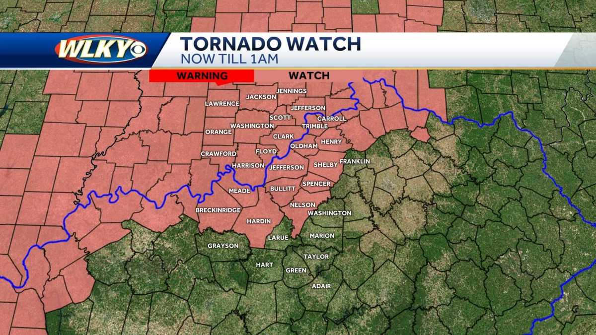
Current Weather Warnings and Watches
As of late Sunday night, all active Tornado Warnings in the WLKY viewing area have expired. A Tornado Watch remains in effect until 1 a.m. for Louisville and many surrounding counties.
Key Updates:
- 10:37 p.m.: Meade County RECC reports 5,600 people are without power across its six-county service area, including Meade, Breckinridge, and Hardin Counties. Crews are working to restore power. People are warned to stay away from downed power lines.
- 10:22 p.m.: A Severe Thunderstorm Warning is in effect until 9:45 p.m. CDT for Hart County.
- 10:17 p.m.: Washington County is under a Tornado Warning until 10:45 p.m.
- 10:16 p.m.: Flash Flood Warning issued including New Pekin, Palmyra, and Marengo in Indiana until 1:15 a.m.
- 10:14 p.m.: Severe Thunderstorm Warning including Elizabethtown, Hodgenville, and New Haven until 10:30 p.m.
- 10:00 p.m.: Spencer County is under a Tornado Warning until 10:15 p.m.
- 9:55 p.m.: Tornado Warning issued for Bardstown, Shepherdsville, and Lebanon Junction in effect until 10:15 p.m.
- 9:46 p.m.: Tornado Warning issued for southern Louisville and northern Bullitt County, including Mount Washington, Hillview, and Brooks in effect until 10:15 p.m. Jeffersontown, West Buechel, and Heritage Creek are included.
- 9:38 p.m.: Severe Thunderstorm Warning issued including Louisville, Hillview, and Brooks in Kentucky until 10 p.m.
Earlier Warnings and Statements
Here’s a recap of the earlier weather alerts issued throughout the day:
- 9:24 p.m.: Tornado Warning expanded to include Meade County, western portions of Bullitt County, and northern Hardin County until 10 p.m.
- 9:15 p.m.: Tornado Warning including Hardinsburg, Irvington, and Custer, Kentucky in effect until 8:45 p.m. CDT.
- 9:10 p.m.: The mainline appears to be weakening, but damaging hail and straight-line winds are possible as storms slowly move east across Kentucky, southern Indiana toward the Louisville area.
- 8:27 p.m.: A special weather statement has been issued advising of pea-sized hail for Charlestown, Sellersburg, and Henryville in Indiana until 8:45 p.m.
- 8:20 p.m.: Severe Thunderstorm Warning issued including Corydon, Georgetown, and Galena in Indiana until 8:30 p.m.
- 7:50 p.m.: Severe Thunderstorm Warning issued including Salem, New Pekin, Palmyra in Indiana until 8:15 p.m.
- 7:44 p.m.: Severe Thunderstorm Warning issued including Paoli, French Lick, and West Baden Springs in Indiana until 8:15 p.m.
- 7:27 p.m.: A special weather statement advising of possible half-inch-size hail has been issued for Marengo, English, and Valeene in Indiana until 7:45 p.m.
- 7:25 p.m.: Severe Thunderstorm Warning issued including Jasper, Huntingburg, Holland in Indiana until 7:45 p.m.
- 7:20 p.m.: Severe Thunderstorm Warning issued including Jasper, Paoli, and Orleans in Indiana until 7:30 p.m.
Tornado Watch Issued
Earlier in the day, a tornado watch was issued for parts of Indiana, Kentucky, and Ohio until 1 a.m.
6:45 p.m.: A tornado watch has been issued for parts of Indiana, Kentucky, and Ohio until 1 a.m.
1:00 p.m.: A tornado watch has been issued for parts of Illinois, Indiana, Kentucky, and Missouri until 8 p.m. EDT. Counties in Indiana include Brown, Greene, Knox, Lawrence, Martin, Monroe, and Sullivan. Kentucky counties include Daviess, Henderson, and Union.
Sunday’s Weather Timeline
A timeline of weather events throughout Sunday:
- 5:00 p.m.: Watch the latest forecast with Jay Cardosi and Eric Zernich as severe weather moves closer to the Louisville area.
- 4:15 p.m.: A band of heavy rain with some thunder quickly moves through the downtown Louisville area.
- Strong storms with the possibility of damaging winds, hail, and isolated tornadoes will move into the WLKY viewing area.
The timing looks to be late day Sunday into the very early morning hours of Monday.
Severe Weather Outlook
All forms of severe weather may develop–damaging winds, large hail, and the potential for strong tornadoes are all possible. The Storm Prediction Center has placed the WLKY viewing area under an ‘Enhanced’ risk, which is a level 3 out of 5 on the severity scale.
We will keep a close eye on the potential for damaging winds, large hail, and isolated tornadoes. This storm line is expected to move through the area quickly and clear out by early Monday morning.
Monday’s Forecast
Temperatures on Monday will likely drop throughout the day, settling into the 50s.
Conclusion
While the immediate threat of tornadoes has passed, it’s essential to remain vigilant and stay informed. A tornado watch remains in effect, and scattered showers are still possible. Continue to monitor weather updates and heed any warnings issued by local authorities.
Stay safe, Louisville, and remember to download the WLKY app for up-to-date weather alerts.
Leave a Reply