As the day winds down, Central Florida residents, particularly those in and around Orlando, need to stay vigilant. A potent squall line, currently positioned over Tallahassee, is generating severe storms and charting a course that may impact our region tonight. Understanding the potential risks and taking necessary precautions is crucial for ensuring safety.
This weather event has the potential to disrupt travel, outdoor activities, and even daily routines. FYM News is committed to providing you with the most accurate and up-to-date information so you can make informed decisions. This article will delve into the specifics of the approaching storm, potential impacts, and safety measures to keep you and your loved ones safe.
We’ll cover the expected timeline, affected areas, and the strength of the storm as it moves closer to Orlando. Additionally, we’ll provide guidance on how to prepare for severe weather and what actions to take during the storm. Stay with FYM News for comprehensive coverage and real-time updates.
Squall Line Development and Current Status
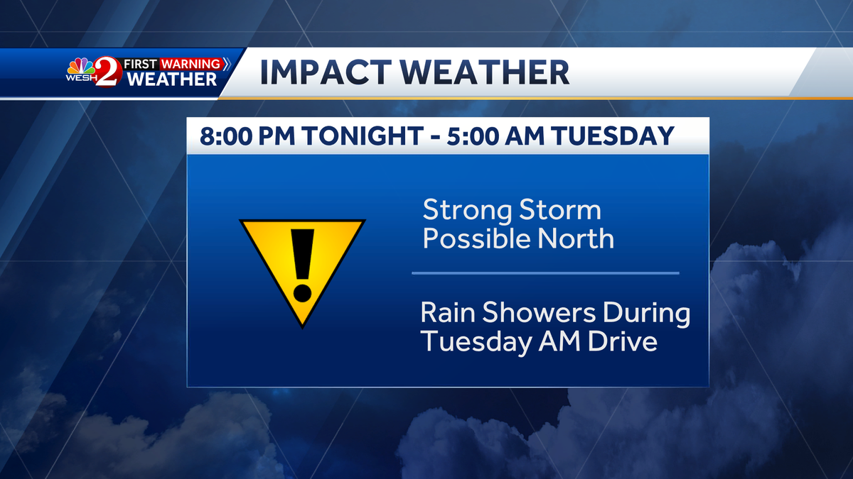
A squall line, characterized by its linear structure of thunderstorms, is currently developing over Tallahassee. This line is producing severe storms and possesses the potential to maintain its intensity as it advances towards Central Florida. While there is anticipation that the squall line will weaken as it progresses southward, the possibility of robust storms impacting areas north of Orlando remains a concern.
Meteorologists are closely monitoring the squall line’s trajectory and intensity. According to First Warning Weather, the line is expected to weaken as it moves south over Orlando around midnight to early Tuesday morning. However, residents should remain vigilant as weather patterns can shift rapidly.
Understanding the nature of squall lines is crucial for preparedness. These weather systems are known for their capacity to produce damaging winds, heavy rainfall, and even isolated tornadoes. It is imperative to stay informed through local news channels and weather apps to receive timely updates and alerts.
Keep an eye on the radar and heed any warnings issued by local authorities. Proactive measures can significantly reduce the risk of property damage and personal injury. Stay tuned to FYM News for live coverage and expert analysis as the situation evolves.
Potential Impacts on Orlando and Surrounding Areas
The primary concern regarding the approaching squall line is the potential for severe weather conditions in Orlando and its neighboring areas. While the storm is projected to weaken as it moves southward, residents should still prepare for the possibility of strong winds, heavy rainfall, and localized flooding.
Areas north of Orlando may experience the most significant impacts. Marion and Sumter counties are particularly vulnerable to damaging wind gusts and potential flash flooding. It is advisable for residents in these regions to secure outdoor furniture, trim trees, and clear drainage systems to minimize property damage.
Even with the anticipated weakening, Orlando itself could still face challenges. Commuters should be prepared for possible delays due to inclement weather. The early Tuesday morning drive may see lingering showers, impacting visibility and road conditions. Staying informed about real-time traffic updates and weather alerts is highly recommended.
Furthermore, outdoor activities should be postponed or adjusted. The risk of lightning strikes increases during thunderstorms, making it unsafe to be outside. Always prioritize safety and be ready to seek shelter indoors if the weather deteriorates rapidly.
Current Weather Advisories and Warnings
As of the latest update, there are no active weather advisories specifically for Orlando. However, this does not mean the region is entirely out of risk. The situation remains dynamic, and weather conditions can change swiftly. It is essential to stay informed and heed any future warnings issued by local authorities.
The absence of current advisories should not lead to complacency. Residents are encouraged to monitor weather updates regularly and have a plan in place in case severe weather does strike. Knowing where to seek shelter and having emergency supplies readily available can make a significant difference.
Pay close attention to any alerts issued by the National Weather Service. These alerts provide crucial information about potential hazards and recommended actions. Staying connected through weather apps and local news channels ensures you receive timely notifications.
Remember, proactive preparedness is key to mitigating the risks associated with severe weather. Even if there are no immediate threats, being ready can provide peace of mind and enhance safety.
Expert Analysis from the First Warning Weather Team
The First Warning Weather team at WESH 2, including Chief Meteorologist Tony Mainolfi, Eric Burris, Kellianne Klass, Marquise Meda, and Cam Tran, is closely monitoring the approaching squall line and providing expert analysis to keep Central Florida residents informed.
Their expertise and advanced weather forecasting tools enable them to predict potential impacts accurately. By staying tuned to their updates online and on-air, you can receive the most accurate and reliable weather information available. The First Warning Weather team is committed to keeping you safe during severe weather events.
Download the WESH 2 News app to receive real-time weather alerts and forecasts directly to your mobile device. This ensures you stay informed even when you’re on the go. The app provides up-to-date radar, severe weather alerts, and personalized notifications tailored to your location.
Trust the First Warning Weather team to provide the insights you need to make informed decisions. Their dedication to accuracy and community safety makes them a valuable resource during severe weather situations.
Understanding Impact Weather and Severe Weather Warning Days
It’s crucial to understand the difference between Impact Weather and Severe Weather Warning Days. Impact Weather signifies weather conditions that could be disruptive or a nuisance to travel and daily activities. This includes conditions like heavy rain, strong winds, and reduced visibility.
On the other hand, a Severe Weather Warning Day indicates weather conditions that could potentially harm life or property. This involves more dangerous events such as tornadoes, derechos, and flash floods.
By understanding these distinctions, residents can better assess the level of risk and take appropriate actions. During Impact Weather, it’s essential to adjust your plans and take precautions to minimize disruptions. On Severe Weather Warning Days, it’s crucial to seek shelter immediately and follow safety guidelines.
Stay informed about the specific type of weather event expected and heed any warnings issued by local authorities. This knowledge will help you make informed decisions and protect yourself and your loved ones.
Key Takeaways and Final Thoughts
In summary, a potent squall line is developing over Tallahassee and may impact areas in Orlando tonight. While the storm is expected to weaken as it moves southward, residents should remain vigilant and prepare for the possibility of strong winds, heavy rainfall, and localized flooding.
Stay informed by monitoring weather updates regularly through local news channels, weather apps, and the National Weather Service. The First Warning Weather team at WESH 2 is closely tracking the storm and providing expert analysis to keep you safe. Download their app to receive real-time alerts and forecasts.
Take proactive measures to secure your property, adjust your plans, and be ready to seek shelter if severe weather strikes. Understanding the difference between Impact Weather and Severe Weather Warning Days can help you assess the level of risk and take appropriate actions.
Remember, preparedness is key to mitigating the risks associated with severe weather. By staying informed and taking necessary precautions, you can protect yourself and your loved ones during these events. Stay safe, Central Florida!
Leave a Reply