Des Moines, Iowa, is bracing for a significant shift in weather patterns. After a relatively mild Sunday with increasing cloud cover, the region faces a potential for strong to severe storms on Monday. Residents are urged to stay informed and prepared as the conditions develop. This article provides a detailed outlook on the expected weather changes, potential hazards, and necessary precautions to ensure safety.
Understanding the dynamics of severe weather is crucial for minimizing risks. The upcoming storm system presents a range of threats, including large hail, damaging winds, and possible tornadoes. Awareness and preparedness are key to navigating these challenges effectively. Stay tuned for a comprehensive breakdown of what to expect and how to protect yourself and your property.
With the arrival of potentially severe weather, it’s essential to have a plan in place. This includes knowing where to seek shelter, how to stay updated on weather alerts, and what steps to take before, during, and after a storm. Let’s delve into the specifics of the forecast and outline the best strategies for staying safe during this weather event.
Cloudy Sunday Precedes Stormy Monday
Des Moines started Sunday with temperatures in the mid-40s to low 50s, a slight increase from previous days. Clear overnight skies gave way to increasing cloud cover, which is expected to persist throughout the day. While a few spotty showers are possible, most of the day should remain dry. The southeast breeze will pick up, potentially gusting up to 25 mph in the afternoon. These conditions set the stage for the more significant weather changes expected on Monday.
The transition from a calm Sunday to a potentially turbulent Monday highlights the importance of staying informed. These initial conditions provide a stark contrast to the forecast for the following day. The increasing humidity and rising temperatures are key factors contributing to the development of severe storms.
“Even warmer, windier, and more humid weather arrives tomorrow, setting the stage for potential severe storms,” according to local meteorologist David Koeller. This early assessment underscores the need for residents to prepare for a rapid change in weather conditions. Early preparation is essential for minimizing the impact of severe weather events.
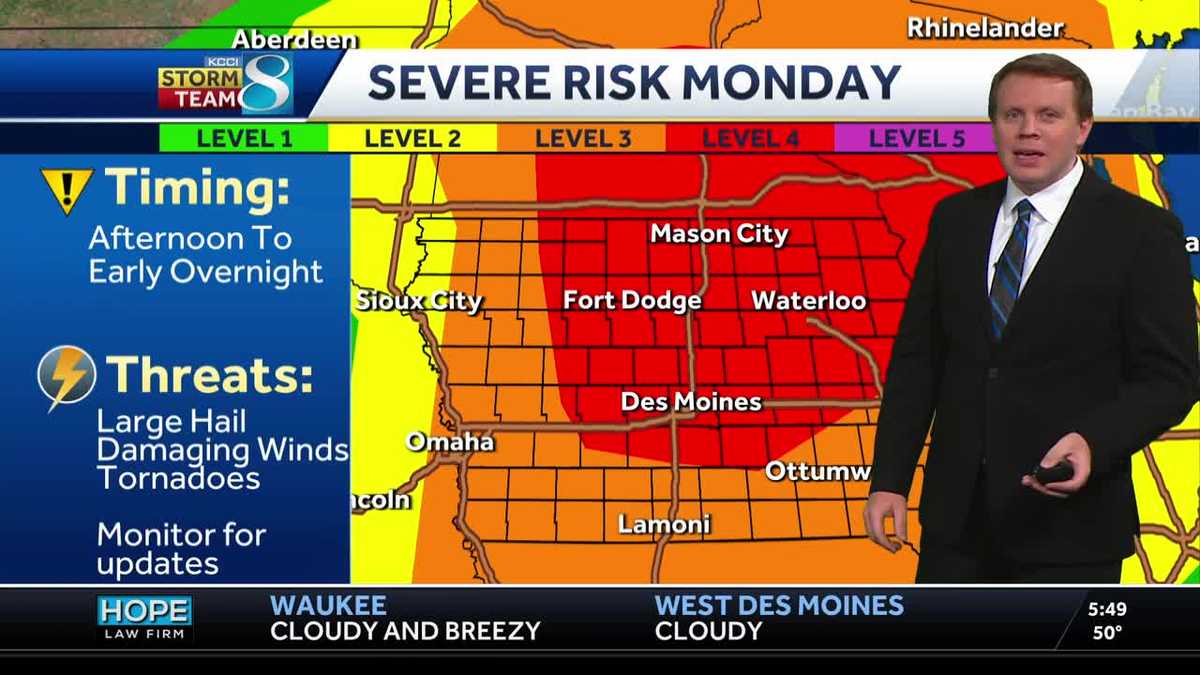
Monday’s Severe Weather Threat: What to Expect
Monday brings a significant risk of severe weather to Des Moines and surrounding areas. As morning clouds give way to sunshine, gusty south-to-southwest winds could reach up to 40 mph. High temperatures are expected to climb into the low 80s, accompanied by increasing humidity. This combination creates a favorable environment for thunderstorm development. Be prepared for rapidly changing conditions as the day progresses.
The primary threat for severe weather is expected to develop along a wind shift or dry line pushing into western Iowa by early afternoon. It remains uncertain how widespread these storms will be or if they will move into central Iowa. However, any storms that form will be capable of producing very large hail, damaging winds, and even a few tornadoes. Stay vigilant and monitor weather updates throughout the day.
Meteorological models suggest a high likelihood of severe weather. “Any storms that are able to form will be capable of significant severe weather including very large hail, damaging winds, and a few tornadoes,” reports Koeller. Residents are strongly advised to stay updated on the forecast and have a severe weather plan ready.
Potential Impacts and Safety Measures
The potential impacts of Monday’s storms include significant property damage from large hail and strong winds, as well as the risk of injury from tornadoes. It is critical to take proactive measures to protect yourself and your property. Secure outdoor objects that could become projectiles in high winds, and ensure your vehicle is parked in a safe location, away from trees and power lines.
During a severe thunderstorm or tornado warning, seek shelter immediately. The safest place is an interior room on the lowest level of a sturdy building. Stay away from windows and exterior walls. If you are in a vehicle or outdoors, find the nearest substantial shelter. Monitor local news and weather alerts for the latest information.
“Be sure to stay updated on the forecast and have your severe weather plan ready in case storms threaten your area,” warns the local weather authority. This reinforces the need for a well-thought-out plan. Knowing where to go and what to do can make a significant difference in ensuring your safety during severe weather.
Extended Forecast: What’s Ahead
Following Monday’s storms, cooler and breezier conditions are expected for Tuesday, with highs in the low to mid-60s. Rain chances return by Wednesday, particularly late into the night and overnight, especially over southern and southeast Iowa. The end of the week brings a return to sunshine, with temperatures climbing back into the 70s by the upcoming weekend. This fluctuating pattern highlights the dynamic nature of Iowa weather in the spring.
While the immediate focus is on Monday’s severe weather potential, it’s essential to stay aware of the broader weather trends. Knowing what to expect in the coming days can help you plan accordingly and remain prepared for any weather-related challenges. Keeping an eye on long-range forecasts can prevent surprises.
The extended forecast indicates a return to more stable conditions after the midweek rain. “Sunshine is back in the forecast for the end of the week, with highs back into the 70s by the upcoming weekend,” confirms the forecast. This offers a positive outlook for those looking forward to outdoor activities and warmer weather.
Des Moines Specific Forecast
Here’s a breakdown of the forecast specifically for Des Moines:
- Today: Mainly cloudy with a possible spotty shower in the morning. High of 64F. Winds SE at 10 to 20 mph.
- Tonight: Cloudy with a possible spotty shower or storm after Midnight. Low of 57F. Winds SSE at 15 to 25 mph.
- Tomorrow: Partly cloudy and windy. Scattered thunderstorms possible in the afternoon and evening, with potential for strong to severe storms. High of 83F. Winds S at 25 to 35 mph.
- Tomorrow Night: Storms in the evening and early overnight, with strong to severe potential. Gusty winds diminishing after midnight. Low of 44F. Winds W at 20 to 30 mph.
This detailed forecast provides a clear picture of what to expect in Des Moines. Residents can use this information to make informed decisions and take the necessary precautions to stay safe during the expected weather events. Localized forecasts are invaluable for planning.
Conclusion: Staying Safe and Informed
In summary, Des Moines is preparing for a cloudy Sunday followed by a potentially severe weather event on Monday. Residents are encouraged to stay informed about the evolving weather conditions and take proactive steps to protect themselves and their property. By understanding the risks and following safety guidelines, you can minimize the impact of severe weather.
Key takeaways include the importance of monitoring weather alerts, having a well-defined severe weather plan, and securing your property against potential damage. Remember, being prepared can make a significant difference in ensuring your safety and well-being. Community resilience depends on individual preparedness.
As the storm system approaches, stay connected with local news and weather updates. The FYM News website will provide continuous coverage and timely alerts to keep you informed. Together, we can navigate these weather challenges and ensure a safe outcome for our community. Staying vigilant and informed are the best defenses against severe weather impacts.
Leave a Reply