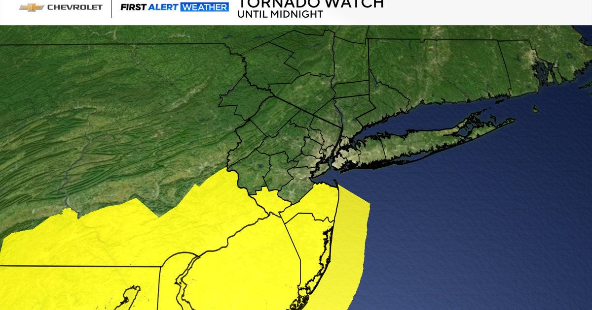
A tornado watch has been issued for parts of New Jersey, particularly Monmouth and Ocean counties, as severe storms are expected to intensify. This alert, issued by the National Weather Service, remains in effect until midnight. Residents in the affected areas should stay informed and prepared for potential weather hazards. This article provides a comprehensive overview of the situation, including the risks, affected areas, and necessary precautions.
Understanding the dynamics of these storms is crucial for ensuring safety and minimizing potential damage. The combination of heavy rain, thunderstorms, and the possibility of tornadoes poses a significant threat. Being aware of these risks allows individuals and communities to take proactive measures to protect themselves and their property.
This article will cover the specific areas under the tornado watch, the potential for severe thunderstorms and flooding, and the expected weather patterns for the coming days. Additionally, it will offer practical advice on how to stay safe during severe weather events. Stay tuned for detailed information and guidance to help you navigate this weather situation.
Tornado Watch in Effect for Monmouth and Ocean Counties
The National Weather Service has issued a tornado watch for Monmouth and Ocean counties in New Jersey, effective until midnight. This alert indicates that conditions are favorable for tornadoes to develop in these areas. Residents should remain vigilant and monitor weather updates closely.
According to CBS New York, the tornado threat is a significant concern, although the probability is relatively low at 2-5%. Even with a small percentage, the potential for tornadoes cannot be ruled out, especially in central and southern New Jersey. It’s essential to have a plan in place in case a tornado warning is issued.
The tornado watch means that residents should:
- Stay informed by monitoring local news and weather alerts.
- Identify a safe place to take shelter, such as a basement or interior room.
- Be prepared to act quickly if a tornado warning is issued.
The combination of a low-pressure area and atmospheric conditions creates an environment where tornadoes can form. Staying prepared and informed is the best way to ensure safety during this period.
Severe Storm and Flood Risks
Aside from the tornado threat, the region faces risks from severe thunderstorms and heavy rainfall. The same weather system that could produce tornadoes is also expected to bring torrential rain, leading to potential flooding.
CBS New York reports that rainfall amounts could reach 1-2 inches, with even higher totals in some locations. This level of rainfall can quickly lead to localized and flash flooding, particularly in areas with poor drainage. It’s crucial to take precautions to protect property and ensure personal safety.
To mitigate flood risks, residents should:
- Clear gutters and downspouts to ensure proper water flow.
- Move valuable items to higher levels in your home.
- Avoid driving through flooded areas.
- Stay informed about flood warnings and advisories.
The areas north and west of the city are at the highest risk of flooding, according to weather forecasts. Residents in these regions should be particularly vigilant and prepared.
Saturday’s Weather Forecast: More Thunderstorms
The unsettled weather pattern is expected to continue into Saturday, with more showers and thunderstorms predicted for the afternoon and early evening. Although the severe threat may be diminished compared to Friday night, it’s still essential to stay alert.
According to CBS New York, a lull in activity is expected by late Saturday morning before another round of storms moves into the region. This break in the weather could provide a brief opportunity to assess any damage and prepare for the next wave of inclement weather.
Key points for Saturday’s forecast:
- Another round of showers and thunderstorms in the afternoon and early evening.
- Diminished but still present severe weather threat.
- Clearing skies and lower humidity expected by Sunday.
Residents should continue to monitor weather updates and take necessary precautions to stay safe during the ongoing storms.
Looking Ahead: Weekend Weather Outlook
Following the stormy conditions on Friday and Saturday, the weather is expected to improve significantly by Sunday. Clearing skies and lower humidity will bring relief to the region.
CBS New York forecasts that high temperatures will drop from the low 70s on Saturday to the upper 60s by Sunday. This cooler, drier air will provide a welcome change after the heavy rain and thunderstorms.
The outlook for the upcoming week includes:
- Much warmer temperatures, reaching into the 80s.
- More stable and pleasant weather conditions.
Residents can look forward to a more favorable weather pattern as the new week begins, with warmer temperatures and sunny skies.
Essential Safety Tips for Severe Weather
During severe weather events, it’s crucial to prioritize safety and take appropriate precautions. Here are some essential tips to help you stay safe during tornadoes, thunderstorms, and floods:
- Tornadoes: Seek shelter in a basement or interior room away from windows.
- Thunderstorms: Avoid contact with electrical appliances and stay indoors.
- Floods: Do not drive or walk through flooded areas.
- General Preparedness: Have an emergency kit with essential supplies.
- Stay Informed: Monitor weather alerts and local news for updates.
Having a well-prepared emergency plan can make a significant difference in ensuring your safety and the safety of your loved ones.
Live Radar Around the Tri-State Area
Staying informed about the current weather conditions is essential during severe weather events. Accessing live radar can provide real-time updates on storm movements and potential impacts.
CBS New York provides a live radar map for the Tri-State Area, allowing residents to track the progress of storms and make informed decisions. This tool is invaluable for staying ahead of the weather and taking necessary precautions.
Key features of the live radar include:
- Real-time tracking of storm movements.
- Detailed views of precipitation and weather patterns.
- Up-to-date information on weather alerts and warnings.
By using live radar, residents can stay one step ahead of the storm and ensure their safety.
Conclusion: Staying Safe During Severe Weather
In summary, a tornado watch has been issued for parts of New Jersey, including Monmouth and Ocean counties, as severe storms are expected to impact the region. Residents should remain vigilant, stay informed, and take necessary precautions to protect themselves and their property.
The combination of potential tornadoes, severe thunderstorms, and heavy rainfall poses significant risks. By following the safety tips outlined in this article and staying updated with the latest weather alerts, you can minimize the impact of these events.
Remember the key takeaways:
- Monitor local news and weather alerts for updates.
- Have a plan in place for seeking shelter during a tornado.
- Take precautions to prevent flood damage.
- Stay informed about changing weather conditions.
By staying prepared and informed, you can navigate severe weather events safely and confidently. The FYM News team is committed to providing you with the latest information and guidance to help you stay safe.
Leave a Reply