Western Nebraska is bracing for severe storms this Sunday evening, with potential threats including large hail, strong winds, and possible brief spin-up tornadoes. FYM News is committed to keeping you informed and safe during this weather event. This article provides a detailed forecast, safety tips, and the latest updates to help you prepare for the approaching storms. Stay tuned as we bring you live coverage and expert analysis to ensure you and your loved ones remain protected.
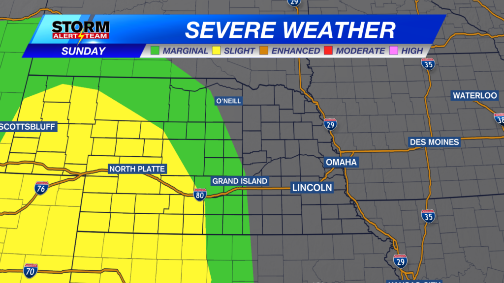
The primary areas at risk include west-central and southwestern Nebraska, with surrounding regions like Grand Island under a marginal risk. The main concerns revolve around significant hail, potentially reaching the size of tennis balls, and winds exceeding 75 mph. A few isolated tornadoes are also a possibility. Our goal is to equip you with the knowledge to navigate these conditions safely.
Sunday’s Severe Weather Outlook
On Sunday, a slight risk of severe weather looms over west-central and southwestern Nebraska. Grand Island and its surrounding areas face a marginal risk. The forecast indicates that large hail, potentially up to tennis ball size, and winds exceeding 75 mph are the primary threats. Isolated, brief tornadoes could also develop as storms evolve through the evening.
Initial storm cells may produce large hail and exhibit brief rotations. Later in the evening, a line of storms moving from Colorado is expected to bring heavy rain, damaging winds, and additional large hail as it progresses through southwestern Nebraska. Fortunately, these storms are predicted to weaken before reaching the Grand Island area.
The convergence of these storms may lead to the formation of an MCS (Mesoscale Convective System) as they push east-southeast throughout Sunday night. The winds are expected to be a significant factor, potentially reaching 75+ mph, posing risks to property and personal safety.
Monday’s Storm Potential
The severe weather threat extends into Monday, with a similar storm system expected to develop in the evening. These storms will initiate out west and move eastward overnight. The primary concerns remain large hail, potentially reaching tennis ball size, and high winds exceeding 75 mph. There is a possibility that this risk could shift further east into southeastern Nebraska as the forecast evolves.
Residents are advised to stay vigilant and monitor weather updates closely. Keep mobile devices charged and ensure access to weather alerts. Monday’s forecast introduces additional uncertainties, so preparations and awareness are crucial.
Tonight’s Conditions and Temperatures
Tonight, temperatures are expected to range in the mid to upper 60s across the region. Expect a muggy night under partly cloudy skies. An isolated shower could linger in some parts of the state. The overnight conditions will set the stage for Sunday’s weather patterns, emphasizing the importance of staying informed.
The combination of muggy conditions and potential isolated showers underscores the need for residents to remain attentive to changing weather conditions. Check local forecasts before bedtime and ensure that you have a plan in place should severe weather develop overnight.
Extended Forecast Through the Week
Scattered storm chances will persist through Wednesday. A front is expected to move through on Friday, potentially bringing additional storm chances. Models have shown agreement in recent runs, but this forecast is subject to change as the week progresses. Temperatures are expected to remain around average throughout the next week.
With storm chances lingering through the week, it’s essential to stay prepared. Keep an eye on the forecast and ensure that your emergency kits are stocked and easily accessible. Friday’s potential front could bring another round of severe weather, so early preparation is key.
Safety Tips for Severe Weather
In preparation for severe weather, ensure you have a plan in place. Identify a safe room in your home, such as a basement or interior room away from windows. Stay informed by monitoring weather updates from reliable sources like FYM News and local weather channels. Charge your mobile devices and have a battery-powered radio available in case of power outages.
If a severe storm approaches, seek shelter immediately. Avoid driving if possible, and if you are caught outdoors, find the lowest ground possible and protect your head. After the storm passes, be cautious of downed power lines and potential flooding. Stay vigilant and prioritize safety.
Omaha Weather and Regional Impact
While the immediate severe weather risk is focused on western Nebraska, Omaha residents should remain aware of the potential for eastward shifts in the storm patterns. Monitoring Omaha weather forecasts and radar updates will provide valuable insights as the week progresses. Awareness and preparedness are key, even if the most severe conditions are initially expected further west.
Stay tuned to FYM News for continuous updates and live coverage. We are committed to keeping Omaha and the surrounding areas informed and safe. Our expert meteorologists will provide the latest analysis and guidance to help you navigate any weather-related challenges.
Conclusion: Staying Informed and Prepared
As severe storms approach western Nebraska, FYM News remains dedicated to providing you with timely and accurate weather updates. The potential for large hail, strong winds, and isolated tornadoes underscores the importance of preparation and vigilance. Stay informed, stay safe, and rely on FYM News for the latest developments.
Remember to monitor weather forecasts regularly and heed any warnings issued by local authorities. With the possibility of shifting storm patterns, residents throughout Nebraska should remain prepared for severe weather conditions. Together, we can navigate these challenges and ensure the safety of our communities.
Leave a Reply