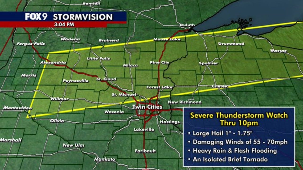
Hot and steamy conditions are expected today in Minneapolis, but change is on the horizon. The National Weather Service has issued a Severe Thunderstorm Watch for the north Twin Cities metro area until 10 p.m. tonight. Residents should be prepared for gusty winds, potential flash flooding, large hail, and even isolated tornadoes. The storms are part of a larger weather pattern affecting much of Minnesota, moving from the north to the south of the state.
The Twin Cities are also under a heat advisory, with temperatures expected to feel like they are in the upper 90s. The combination of heat and potential severe weather makes it crucial for residents to stay informed and take necessary precautions. This article provides an in-depth look at the expected weather conditions, potential risks, and extended forecast for the Minneapolis area.
We’ll cover the specifics of the Severe Thunderstorm Watch, what to expect during the storms, and how to stay safe. Additionally, we’ll provide an extended forecast, giving you a glimpse into the weather conditions expected for the rest of the week. Stay tuned for all the details you need to navigate this potentially hazardous weather event.
Severe Thunderstorm Watch in Effect
A Severe Thunderstorm Watch is currently in effect until 10 p.m. for parts of the north Twin Cities metro, as issued by the National Weather Service. The watch area extends from St. Cloud to Duluth and reaches as far south as St. Michael, Rogers, and Maple Grove. This means that conditions are favorable for severe thunderstorms to develop in and near the watch area.
According to FOX 9 Meteorologist Cody Matz, the primary threats associated with these storms are gusty winds and flash flooding. However, large hail and isolated tornadoes cannot be ruled out. Residents within the watch area should remain alert and monitor weather updates closely. It’s important to have a plan in place in case severe weather strikes.
“The National Weather Service emphasizes the importance of staying informed during a Severe Thunderstorm Watch,” says Matz. “Conditions are ripe for dangerous weather, and it’s crucial to be prepared.” This includes having a reliable source of weather alerts and knowing where to seek shelter if necessary.
Remember, a watch means that severe weather is possible. A warning, on the other hand, means that severe weather is imminent or occurring. During a warning, you should take immediate action to protect yourself and your loved ones.
Tuesday’s Storm Outlook
Today’s weather forecast includes a heat advisory for the Twin Cities until 8 p.m. Temperatures are expected to climb into the lower 90s, and with dew points near 70, it will feel like the mid to upper 90s. This heat will contribute to the development of strong thunderstorms later in the day. A cold front moving across the state will trigger numerous storms in northwestern Minnesota, which will then strengthen as they move southeast into the steamy air mass over southern Minnesota.
The Twin Cities metro area has a level 1 marginal risk of severe weather, while parts of central and western Minnesota face a level 2 slight risk. This means there is a chance of isolated to scattered severe storms from mid-afternoon into the evening. The main threats include hail, strong wind gusts of 60+ mph, localized downpours, and a very low risk of isolated tornadoes.
“The combination of heat and humidity will create an unstable atmosphere, making it easier for storms to develop and intensify,” explains Matz. “It’s important to stay hydrated and take breaks from the heat, especially during the afternoon hours.” He also advises securing any outdoor furniture or objects that could be blown away by strong winds.
The chance of storms increases in the Twin Cities metro later in the evening. Keep an eye on the sky and be prepared to take shelter if a severe thunderstorm warning is issued.
Extended Forecast
Looking ahead, rain and rumbles are expected to linger into the first part of Wednesday, with lighter showers in the afternoon and evening. Temperatures will be cooler from Wednesday through Friday, with highs mainly in the 70s. This will provide a welcome break from the heat and humidity experienced earlier in the week.
Saturday may bring a few more rumbles, with weekend highs in the upper 70s to lower 80s. Overall, the extended forecast suggests a return to more typical summer weather conditions after Tuesday’s storms.
“The cooler temperatures will be a relief after the intense heat,” says Matz. “It’s a good time to open up the windows and enjoy some fresh air.” He notes that the long-term forecast is subject to change, so it’s important to stay updated with the latest information.
Here’s a summary of the seven-day forecast: Wednesday will be rainy with cooler temperatures, Thursday and Friday will be mainly in the 70s, and the weekend will see highs in the upper 70s to lower 80s with a chance of rumbles on Saturday.
Safety Tips During Severe Weather
When severe weather threatens, it’s essential to have a plan and take necessary precautions to protect yourself and your family. Here are some safety tips to keep in mind:
- Stay informed: Monitor weather updates from reliable sources, such as the National Weather Service and local news channels.
- Seek shelter: If a severe thunderstorm warning is issued, seek shelter indoors, preferably in a basement or interior room.
- Avoid windows: Stay away from windows, doors, and outside walls during a thunderstorm.
- Unplug electronics: Unplug electronic devices to protect them from lightning strikes.
- Stay off the phone: Avoid using corded phones during a thunderstorm, as lightning can travel through phone lines.
- Watch for flooding: Be aware of the potential for flash flooding, and avoid driving through flooded areas.
“Safety should always be the top priority during severe weather,” emphasizes Matz. “Taking these precautions can significantly reduce the risk of injury or property damage.” He also recommends having an emergency kit on hand, including water, food, and a flashlight.
Remember, severe weather can be unpredictable, so it’s always better to be prepared than to be caught off guard.
Precautions During the Heat Advisory
With a heat advisory in effect for the Twin Cities, it’s crucial to take steps to stay cool and prevent heat-related illnesses. Here are some precautions to consider:
- Stay hydrated: Drink plenty of water throughout the day, even if you don’t feel thirsty.
- Limit outdoor activities: Avoid strenuous activities during the hottest part of the day, typically between 10 a.m. and 4 p.m.
- Wear light-colored clothing: Choose loose-fitting, light-colored clothing to help your body stay cool.
- Seek air conditioning: Spend time in air-conditioned places, such as shopping malls, libraries, or community centers.
- Check on others: Check on elderly neighbors, friends, and relatives to ensure they are staying cool and hydrated.
“Heat-related illnesses can be serious, so it’s important to take these precautions seriously,” warns Matz. “If you experience symptoms such as dizziness, nausea, or headache, seek medical attention immediately.” He also advises never leaving children or pets in a parked car, even for a short period of time.
By taking these steps, you can protect yourself and others from the dangers of extreme heat.
Conclusion: Staying Safe and Informed
Today’s weather in Minneapolis presents a dual threat: severe thunderstorms and extreme heat. The Severe Thunderstorm Watch for the north Twin Cities metro means that conditions are favorable for dangerous storms to develop. Residents should stay informed, monitor weather updates, and be prepared to take shelter if necessary. The heat advisory adds another layer of concern, requiring precautions to prevent heat-related illnesses.
The combination of gusty winds, potential flash flooding, large hail, and isolated tornadoes makes it crucial to have a safety plan in place. Staying indoors during severe thunderstorms, avoiding windows, and unplugging electronics can significantly reduce the risk of injury or property damage. Likewise, staying hydrated, limiting outdoor activities, and seeking air conditioning can help prevent heat-related illnesses.
As Meteorologist Cody Matz emphasizes, “Staying informed and taking necessary precautions are the keys to staying safe during severe weather and extreme heat.” By following these guidelines, residents can navigate these challenging weather conditions with confidence and protect themselves and their loved ones.
Remember to stay tuned to FYM News for the latest weather updates and alerts. We’re committed to providing you with the information you need to stay safe and informed.
Leave a Reply