Des Moines and much of central Iowa are waking up to a stormy Saturday morning. Expect heavy rainfall and strong wind gusts as a line of storms moves through the area. While the storms are expected to clear out by the afternoon, it’s important to stay informed and prepared. This article provides a detailed overview of the current weather situation, including the timing of the storms, potential impacts, and the forecast for the rest of the weekend and the coming week.
Understanding the weather patterns is crucial for planning your day and ensuring your safety. We’ll delve into the specifics of the storm, the areas most affected, and the expected timeline. Stay tuned for a comprehensive look at what to expect and how to stay safe during this weather event.
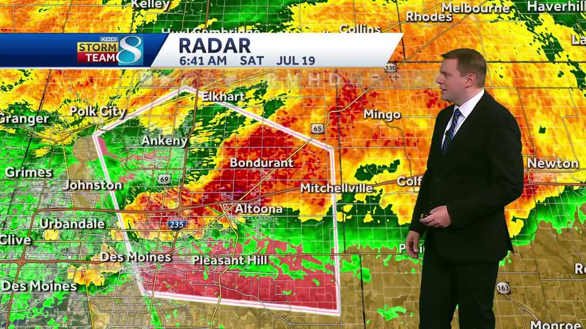
Current Weather Conditions in Des Moines
As of this morning, a line of storms is impacting Des Moines and central Iowa, bringing heavy rainfall and gusty winds. A Severe Thunderstorm Watch is in effect for portions of central and eastern Iowa until 10 AM, including Des Moines and Ames. While widespread severe weather is not anticipated, there is a possibility of wind gusts up to 60 mph in the watch area.
The storms are lining up along the Highway 20 corridor, with rainfall rates of 1 to 2 inches per hour possible in the heaviest downpours. This could lead to short-lived minor flooding, especially in urban or low-lying areas. The line of storms has shown some signs of weakening as it moves south and east, but stronger wind gusts are still possible.
Timing of the Storms
The storms are expected to reach the Des Moines metro area between 6 and 8 AM. If the line of storms holds together, it will continue to push to the east and southeast. Residents in areas like Altoona, Pleasant Hill, and Bondurant should be particularly aware of the potential for heavy rainfall and gusty winds.
A tornado warning was previously in effect for eastern Polk County, but it has since expired. However, it’s essential to stay vigilant and monitor weather updates as conditions can change rapidly. The National Weather Service is closely tracking the storms, and any new warnings will be issued as needed.
Afternoon Weather Outlook
After the morning storms clear out, expect partly sunny skies in the afternoon, helping temperatures climb back into the mid-80s. The heat index is likely to top out around or just above 90 degrees due to the humid conditions. There is a possibility of a few spotty storms this afternoon and early evening, although their coverage and locations will depend on where the morning storms end up.
If a storm develops this afternoon, it could be on the stronger side. Therefore, it’s essential to remain aware of the weather forecast and be prepared for potential changes in conditions.
Weekend Weather Predictions
There is a better chance for more widespread storms late tonight and into Sunday morning, with the rain moving out by mid-morning. Clouds will linger a little longer into Sunday afternoon, helping to keep highs in the low to mid-80s.
Overall, the weekend weather will be a mix of storms and partly cloudy skies, with temperatures remaining relatively warm. It’s a good idea to have indoor activities planned in case of rain and to stay updated on the latest weather forecasts.
Next Week’s Weather Trends
Hotter weather is on the way next week as highs climb into the upper 80s on Monday and the low to mid-90s for Tuesday through Friday. Heat index readings will likely climb above 100 degrees, with the hottest conditions expected on Wednesday. That’s when we’ll see the highest chance for heat index readings above 105 degrees.
It’s important to take precautions to stay cool and hydrated during the upcoming heatwave. Drink plenty of water, wear lightweight clothing, and avoid strenuous activities during the hottest parts of the day. Also, check on elderly neighbors and family members to ensure they are staying safe in the heat.
Detailed Des Moines Forecast
- Today: Morning storms with pockets of heavy rain and gusty winds. Partly cloudy in the afternoon. Isolated storms possible after 5pm. High around 87F. Winds SW at 10 to 15 mph.
- Tonight: Cloudy skies early, then thunderstorms developing late. Low 71F. Winds ENE at 5 to 10 mph.
- Tomorrow: Showers in the morning, then partly cloudy in the afternoon. High 84F. Winds E at 5 to 10 mph.
- Tomorrow Night: Partly cloudy during the evening. A slight chance of storms in northern Iowa overnight. Low 71F. Winds E at 5 to 10 mph.
Conclusion: Staying Safe and Prepared
In summary, Des Moines and central Iowa are experiencing heavy storms this Saturday morning. While the storms are expected to clear by the afternoon, it’s crucial to stay informed and take necessary precautions. The rest of the weekend will bring a mix of weather conditions, with hotter weather arriving next week. Stay hydrated and take steps to stay cool during the expected heatwave.
By staying informed and prepared, you can navigate the weather challenges and ensure your safety and well-being. Keep an eye on local weather updates and adjust your plans as needed to accommodate the changing conditions.
Leave a Reply