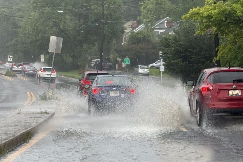
The D.C. region was hit hard by pouring rain and severe storms this Saturday, leading to widespread flash flooding. Water rescues were conducted in areas like Silver Spring and Takoma Park, with vehicles stranded and roads submerged. The heavy rainfall overwhelmed sewers and drainage systems, causing significant disruptions. With more severe weather predicted, residents are concerned about potential impacts on areas like Chevy Chase. Stay informed about the current weather situation and its possible consequences.
Dramatic Water Rescues in Silver Spring
In Silver Spring, dramatic scenes unfolded as two women found themselves trapped in a car floating in high water at the intersection of East-West Highway and Washington Avenue. WTOP’s Dave Dildine reported that the driver described the situation as very scary, noting that what seemed like shallow water quickly turned into approximately five feet of flooding. The car began spinning in the flooded intersection, highlighting the unpredictable nature of the flash flood.
A bystander managed to pull one of the women from the vehicle, while Montgomery County Fire Rescue Services assisted the other to safety. Pierce Tewksbury, who had driven through the area just minutes before, recounted how close he was to being stranded as well. Tewksbury and his brother Stewart bravely entered the waist-high water to help the occupants, emphasizing the importance of quick action in such emergencies.
Tewksbury stated, ‘We saw people were in need of help and I pulled her out of the vehicle, got her over to dry land and waited for the fire department to come.’ He added that the situation could have worsened rapidly, underscoring the potential dangers of flash floods. This event highlights the critical need for awareness and preparedness during severe weather conditions.
Emergency Crews Respond to Takoma Park Flooding
In Takoma Park, Montgomery County fire crews conducted a water rescue after a vehicle became stuck in floodwaters. The driver was found on top of the vehicle and safely brought to higher ground. According to WTOP’s Jimmy Alexander, the presence of an emergency vehicle added to traffic congestion in the area. Officials reported that sewers were backed up, preventing water from draining effectively, and advised people to avoid the area.
The incident in Takoma Park underscores the severity of the flooding and the challenges faced by emergency responders. The combination of heavy rainfall and inadequate drainage created hazardous conditions, necessitating swift and coordinated rescue efforts. The driver’s decision to climb onto the vehicle likely saved them from potentially life-threatening circumstances, emphasizing the importance of staying calm and assessing the situation during a flood.
The backed-up sewers also highlight the infrastructure challenges that contribute to flooding. Addressing these issues will be crucial to mitigating future flood risks in the area.
Road Closures and Travel Disruptions
The flooding led to the closure of Sligo Creek Parkway, along with numerous other roads in the D.C. area, causing significant travel disruptions. The closures affected commuters and residents alike, with many forced to find alternate routes or delay their travel plans. The extent of the road closures reflects the widespread impact of the heavy rainfall and the challenges in managing the floodwaters.
The closure of major thoroughfares like Sligo Creek Parkway not only disrupts daily routines but also poses safety concerns for those who attempt to navigate flooded areas. Authorities urged drivers to avoid flooded roads and to heed warnings to prevent further incidents. The road closures served as a stark reminder of the power of nature and the need for caution during severe weather events.
Motorists should stay informed about road closures and weather advisories through local news channels and official sources to ensure their safety and minimize disruptions.
Sunday’s Forecast: More Storms Possible
While Saturday’s storms caused significant damage, Sunday is expected to bring more of the same, with warm and muggy conditions and a continued risk of severe thunderstorms in the afternoon. However, a cold front is expected to move through Sunday night, bringing beautiful weather with much lower humidity on Monday and Tuesday. The roller coaster of weather conditions highlights the need for residents to remain vigilant and prepared for rapidly changing circumstances.
The potential for severe thunderstorms on Sunday means that residents should monitor weather updates and take necessary precautions to protect themselves and their property. Securing outdoor items, avoiding travel during storms, and having a plan in case of flooding are all essential steps. The expected relief from the cold front on Monday and Tuesday will provide a welcome respite from the stormy weather, but until then, caution is advised.
Sunday night: Showers and storms ending before midnight. Areas of dense fog overnight. Muggy. Lows in the low to mid-70s.
Sunday: Partly sunny, warm and muggy with isolated afternoon and evening thunderstorms. Storms may be severe. Highs in the upper 80s to lower 90s.
Monday: Mostly sunny, cooler and less humid. Highs in the low to mid-80s.
Tuesday: Sunny and pleasant with low humidity. Highs in the low to mid-80s.
Is Chevy Chase Next? Preparing for Potential Flooding
Given the widespread flooding in neighboring areas, residents of Chevy Chase are understandably concerned about the potential for similar conditions. It’s crucial to take proactive steps to prepare for possible flooding. Start by checking local flood maps to understand the area’s flood risk. Ensure that storm drains are clear of debris to facilitate proper water drainage. Have an emergency kit ready with essentials such as water, non-perishable food, flashlights, and a first-aid kit.
Consider flood insurance to protect your property from potential damage. Stay informed about weather updates and heed any warnings issued by local authorities. By taking these measures, residents of Chevy Chase can enhance their preparedness and minimize the potential impact of flooding.
Additionally, consider elevating valuable items in your home and sealing basement walls to prevent water damage. Regular maintenance of your property can also help reduce the risk of flooding. By staying vigilant and taking action, you can protect yourself and your community from the dangers of severe weather.
Stay Safe and Informed
The recent storms and flooding in the D.C. region serve as a reminder of the importance of staying informed and prepared for severe weather. From dramatic water rescues in Silver Spring to road closures across the area, the impact of the storms has been significant. With more potentially severe weather on the horizon, residents should continue to monitor weather updates, take necessary precautions, and stay safe. Remember to check your local weather stations such as WTOP at 103.5 FM or 107.7 FM.
By working together and staying vigilant, we can mitigate the risks associated with severe weather and ensure the safety and well-being of our community. So get custom alerts with the WTOP app for and phones.
Leave a Reply