Indiana is bracing for a day of contrasting weather conditions. Expect high heat and humidity colliding with a slow-moving front, resulting in scattered showers and thunderstorms. A heat advisory is in effect for Indianapolis and areas south, while northern Indiana faces a higher chance of rain and potential cooling. This comprehensive forecast breaks down the timing and location of these weather events to ensure you stay informed and prepared.
Understanding these weather patterns is crucial for planning your day and staying safe. The combination of high heat and potential flash flooding creates hazardous conditions that require vigilance. This guide provides detailed insights into the expected rain zones, potential for severe weather, and overall outlook for the weekend, empowering you to make informed decisions. Whether you’re in Indianapolis or elsewhere in Indiana, this forecast offers the information you need to navigate the day’s weather challenges.
This article covers everything from the approaching front and its impact on different regions, to the risk of flash flooding and the overall weekend forecast. Stay tuned as we delve into the specifics, ensuring you’re well-prepared for whatever the weather may bring.
Heat Advisory and Level 1 Severe Threat
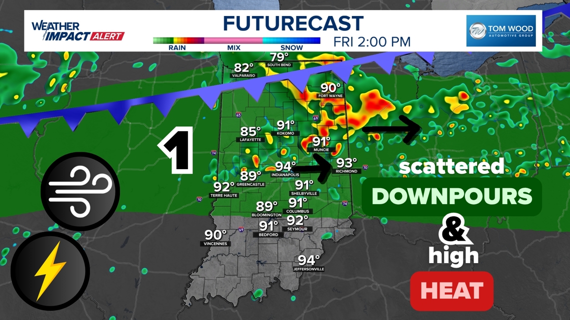
A heat advisory is currently in effect for Indianapolis and regions to the south. This means residents should take extra precautions to stay cool and hydrated, as the combination of heat and humidity can lead to heat-related illnesses. At the same time, a Level 1 severe threat is in place across central Indiana for Friday afternoon. This indicates a possibility of isolated severe thunderstorms, which could bring strong winds, heavy rain, and even small hail.
According to the National Weather Service, “the excessive heat and humidity will significantly increase the potential for heat-related illnesses, particularly for those working or participating in outdoor activities.” They advise drinking plenty of fluids, staying in air-conditioned environments when possible, and checking on vulnerable friends and neighbors. The combination of these factors makes it essential to stay informed and prepared throughout the day.
Steamy Weather Pattern with Scattered Downpours
A humid heat dome over the Ohio River Valley is set to clash with a weak cold front from the north, creating a steamy weather pattern characterized by scattered downpours. This means that while some areas will experience heavy rain and thunderstorms, others will remain relatively dry. The overall weather pattern is expected to be unsettled, with a mix of sun and clouds, and intermittent showers.
Meteorologist Matt Standridge explains that “the front from the north will be very slow moving. It will start in northern Indiana, keeping the highest rain chances there for Friday morning.” He also notes that “hit-or-miss downpours will be possible around Indianapolis and surrounding areas during the afternoon and evening.” This variability in rainfall means that residents should be prepared for changing conditions and monitor local forecasts for the most up-to-date information.
Rain Zones Across Indiana
The chance of rain will vary significantly across Indiana due to the positioning of the slow-moving front. The northern part of the state, particularly areas north of Indianapolis, will have the highest likelihood of rain, especially during the morning hours. Central Indiana, including Indianapolis and its surrounding areas, can expect hit-or-miss downpours during the afternoon and evening. Southern Indiana is likely to remain drier, though isolated heavy downpours are still possible.
Here is a breakdown of the expected conditions based on location:
- Northern Indiana: Highest chance of rain, especially in the morning.
- Central Indiana: Hit-or-miss downpours possible during the afternoon and evening.
- Southern Indiana: Trend drier, but isolated heavy downpours are still possible.
It’s important to note that all rain chances are scattered, meaning not everyone is guaranteed to get wet. Those who stay dry through the morning will likely experience hotter temperatures, while areas that receive rain and lingering clouds can expect slightly cooler, but still humid conditions.
Flash Flooding Threat
The National Weather Service has issued an excessive rainfall outlook for Indiana, indicating a potential for localized flash flooding. The humidity is exceptionally high, with precipitable water values ranging from 2.5 to 3 inches. This means that storms can draw in a significant amount of water, leading to intense rainfall over short periods.
According to the NWS, “very localized flash flooding will be possible for some Hoosiers, while some stay dry today.” They emphasize that “storms will likely not move too quickly, so they can pour over the same locations longer.” This combination of factors increases the risk of flash flooding, particularly in areas prone to poor drainage or low-lying regions. Residents are advised to monitor local alerts, avoid driving through flooded areas, and take necessary precautions to protect their property.
Weekend Outlook
Looking ahead, the unsettled weather pattern is expected to persist throughout the weekend across Indiana. The exact rainfall forecast will depend on the conditions set by previous rounds of rain and cloud cover. However, residents can anticipate a mix of sun and clouds, with scattered showers and thunderstorms at times.
Meteorologists advise taking the rainfall forecast day-by-day, as the dynamic nature of the atmosphere makes precise predictions challenging. While some areas may experience prolonged periods of dry weather, others could see intermittent showers and thunderstorms. It’s essential to stay tuned to local forecasts for the latest updates and be prepared for changing conditions throughout the weekend.
Conclusion
In summary, Indiana faces a day of high heat, scattered storms, and varying rainfall patterns. A heat advisory is in effect for Indianapolis and southern regions, while a Level 1 severe threat looms over central Indiana. The combination of a humid heat dome and a slow-moving front will create unsettled weather conditions, with potential for localized flash flooding. Northern Indiana will likely see the most rain, while southern areas may remain drier.
Staying informed and taking necessary precautions are crucial to navigating these weather challenges. Whether you’re planning outdoor activities, commuting, or simply relaxing at home, awareness of the forecast and potential risks will help you stay safe. Remember to monitor local alerts, stay hydrated, and take steps to protect yourself and your property. The combination of knowledge and preparedness will ensure you’re ready for whatever the weather may bring.
Leave a Reply