Boston faced a day of dangerous heat and severe thunderstorms on Friday, July 25, 2025. A heat advisory was in effect until 8 p.m., with feels-like temperatures exceeding 100 degrees in some neighborhoods. The storms brought strong winds, heavy rain, and hail to the region, causing a ground stop at Logan Airport due to the storms. Fortunately, cooler weather is on its way, promising a more comfortable weekend. Here’s a detailed look at what happened and what to expect.
This weather pattern is crucial for residents to understand so they can take necessary precautions. Knowing when to stay indoors, how to stay safe during extreme heat, and what to expect in the coming days can significantly impact public safety and well-being. This article provides a comprehensive overview, ensuring you are well-prepared for the changing conditions.
This article will cover the immediate impact of the storms and heat, the weekend forecast, and the longer-term weather outlook for Boston. We’ll also provide practical tips for staying safe during severe weather. Keep reading to ensure you’re prepared for whatever Mother Nature throws our way.
Heat Advisory and Safety Measures
A heat advisory was in effect for much of the Boston area until 8 p.m. on Friday. Feels-like temperatures rose above 100 degrees in several neighborhoods, posing a significant risk of heat-related illnesses. Residents were urged to practice heat safety by drinking plenty of water, taking breaks while outdoors, and checking on pets and elderly neighbors.
The combination of high temperatures and humidity created oppressive conditions, making it essential to take precautions. According to the National Weather Service, heat is one of the leading weather-related killers in the United States. Taking simple steps can prevent heat exhaustion and heatstroke.
Here are some tips to stay safe during extreme heat:
- Stay hydrated by drinking plenty of water.
- Avoid strenuous activities during the hottest part of the day.
- Seek out air-conditioned spaces.
- Wear lightweight, light-colored clothing.
- Check on vulnerable neighbors and relatives.
Severe Thunderstorms and Airport Delays
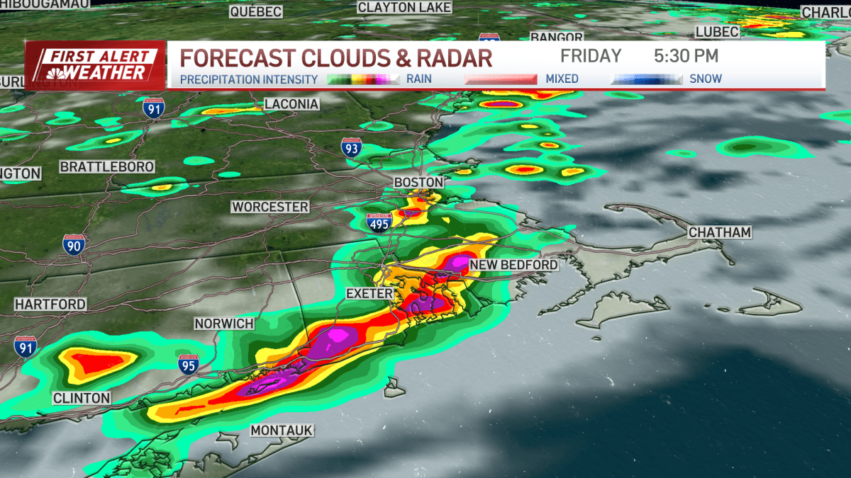
Severe thunderstorm warnings were issued across Massachusetts, including in Boston, as well as in Connecticut and Rhode Island. A severe thunderstorm watch was in place through the evening. These storms brought the risk of gusty winds, heavy rain, and hail. A ground stop was issued at Boston’s Logan Airport due to the storms. Massport indicated that while planes could still take off and land, flights destined for Boston were being held at their origin airports, causing delays.
The storms moved swiftly through the region, impacting travel and outdoor activities. According to the National Weather Service, severe thunderstorms can produce winds exceeding 58 miles per hour and hail larger than one inch in diameter. These conditions can lead to property damage and pose a threat to personal safety.
Here’s how to stay safe during a severe thunderstorm:
- Seek shelter indoors immediately.
- Stay away from windows and doors.
- Avoid using electronic devices connected to electrical outlets.
- If driving, pull over to a safe location and wait out the storm.
Weekend Weather Outlook: Cooler Temperatures Arrive
The arrival of a cold front will dramatically improve conditions this weekend. Storms are expected to clear out of the area before 9 p.m. Friday, giving way to clearing skies and lower humidity. Saturday will feel fantastic with high temperatures in the upper 70s in Boston and in the 80s away from the coast. Expect a mix of sun and clouds.
Sunday will bring a few scattered showers back into the area, but rain is not expected all day. High temperatures will remain comfortable, in the upper 70s and lower 80s. The weekend offers a welcome break from the heat and humidity, making it a great time to enjoy outdoor activities.
Here’s a day-by-day breakdown:
- Saturday: Sunny and partly cloudy, with highs in the upper 70s to low 80s.
- Sunday: Scattered showers, with highs in the upper 70s to low 80s.
Extended Forecast: Heat and Humidity Return Next Week
Early next week, the humidity will return, along with the heat. Highs in the upper 80s and lower 90s are expected on Monday and Tuesday. This return to warmer conditions means residents will need to be prepared to resume heat safety measures.
The ten-day forecast indicates a fluctuating pattern of temperatures and humidity. Staying informed and prepared is key to managing these changes effectively. Monitor local weather updates and adjust your activities accordingly.
Here’s a glimpse into the early part of next week:
- Monday: Highs in the upper 80s, with increasing humidity.
- Tuesday: Highs in the lower 90s, with continued high humidity.
Track the Storms with Interactive Radar
Stay updated on the storm’s progress with our interactive radar. Track the movement of thunderstorms and monitor conditions in real-time. This tool allows you to see where the storms are headed and how they might affect your area. Access the interactive radar on our website or mobile app for the latest information.
The interactive radar provides detailed views of precipitation, wind speeds, and other critical weather data. This feature is invaluable for making informed decisions about your safety and activities during severe weather events.
Use the interactive radar to:
- Monitor storm intensity and direction.
- View detailed precipitation patterns.
- Assess potential risks in your specific location.
Boston experienced a day of challenging weather conditions with dangerous heat and severe thunderstorms. The heat advisory prompted safety measures, while the storms caused travel delays and potential hazards. Fortunately, cooler weather is on its way, offering a much-needed respite this weekend.
Key takeaways from this weather event include the importance of heat safety, the impact of severe thunderstorms, and the fluctuating nature of Boston’s weather patterns. Staying informed and prepared is crucial for managing these conditions effectively.
As we look ahead, it’s clear that monitoring the weather and taking appropriate precautions will remain essential. Whether it’s extreme heat, severe storms, or the return of humidity, being proactive can make a significant difference in ensuring your safety and well-being. Stay tuned to FYM News for the latest updates and forecasts, and continue to prioritize safety as we navigate the changing seasons.
Leave a Reply