Des Moines, Iowa, is bracing for a night of potentially severe weather. Strong storms are expected to move through the area, bringing with them the risk of damaging winds and possible power outages. Residents are urged to stay informed and take necessary precautions to ensure their safety. This article provides the latest weather updates and offers guidance on how to prepare for and handle potential power disruptions.
The approaching storms pose a significant threat, particularly due to the risk of gusty winds. Understanding the timing and intensity of these storms is crucial for effective preparation. Additionally, knowing how to respond to a power outage can minimize inconvenience and ensure safety. Stay tuned for detailed forecasts, safety tips, and resources to help you navigate this weather event.
Iowa Weather: Strong Storms Moving In
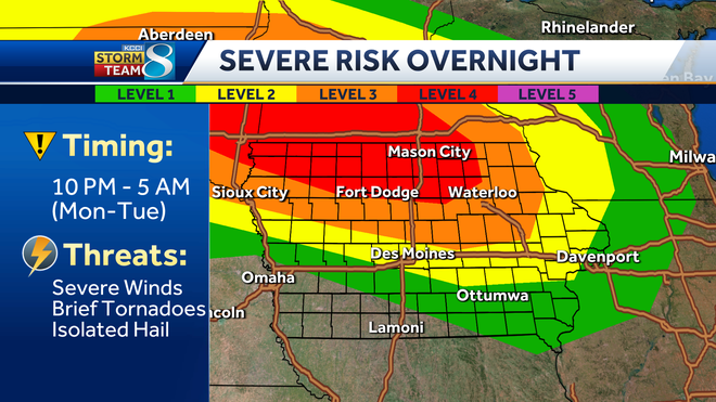
According to KCCI, a significant storm is currently pushing through northwestern Iowa. As of 10:24 PM CDT on July 28, 2025, reports indicate wind gusts around 80 mph. Some areas in northwestern Iowa have already experienced gusts up to 90 mph. A severe thunderstorm warning is in effect until 11:15 PM, and a new warning is expected to be issued as the storm continues eastward.
Locations near Sioux Center have reported wind gusts between 60 and 90 mph. The storm line is expected to surge eastward, with the strongest winds highlighted in pink and orange just south of Sibley. These winds have the potential to be destructive, with radar indications suggesting they could reach 80 to 90 mph in some spots. Winds in excess of 60 mph are possible along the entire line.
Storm Track and Expected Arrival Times
The storm is moving eastward at approximately 50 to 60 mph. Here are the estimated arrival times for various locations:
- Everly: Arriving in 1 minute
- Linn Grove: Arriving in 10 minutes
- West Okoboji: Arriving in 11 minutes
It’s important to monitor the southern edge of this storm line as it continues to surge eastward. A new severe thunderstorm watch is in place, including Polk County and the northern half of the state, excluding a few counties west towards Omaha.
Overnight and Early Morning Forecast
The severe thunderstorm watch remains in effect for the northern half of Iowa. As the storm line moves beyond I-35, it is expected to weaken somewhat. However, the air remains conducive to storm development, and severe characteristics are likely to persist as the storm pushes through.
The line is expected to surge eastward towards Algona and Fort Dodge, crossing over I-35 around midnight. By 2:00 AM, areas including Waterloo, Marshalltown, and Grinnell will likely experience the storm. After this point, the line should weaken as it moves through eastern Iowa. Much of the northern half of the state remains under threat for winds of 60 to 70 mph, potentially reaching 80 mph in some areas.
Tuesday and Wednesday Weather Outlook
Isolated showers may occur into Tuesday morning in the northern part of the state. By Tuesday evening, more showers and thunderstorms are expected, potentially bringing heavy rain. Rainfall totals could range from 1 to 2 inches, with some areas receiving up to 3 or 4 inches.
Damaging winds will be followed by heavy rain. Temperatures will cool down, with highs in the mid-70s by Wednesday and continuing through the end of next weekend. Humidity will also decrease, providing much-needed relief.
Preparing for Potential Power Outages
Given the high likelihood of strong storms and gusty winds, residents should prepare for potential power outages. Here are some essential steps to take:
- Charge Devices: Ensure all mobile devices, laptops, and power banks are fully charged.
- Emergency Kit: Prepare an emergency kit with flashlights, batteries, a first-aid kit, and non-perishable food.
- Stay Informed: Monitor local weather reports and updates from trusted sources like KCCI and FYM News.
What to Do During a Power Outage
If a power outage occurs, follow these guidelines to ensure safety and minimize disruption:
- Use Flashlights: Avoid using candles, which can be a fire hazard.
- Unplug Electronics: Protect your devices from power surges when electricity is restored.
- Conserve Phone Battery: Limit phone usage to essential communications.
- Check on Neighbors: Ensure the safety and well-being of elderly or vulnerable neighbors.
Iowa Weather Forecast
- Tonight: More storms, especially across northern Iowa. Severe winds possible. Low 75F. Winds SSE at 5 to 10 mph.
- Tomorrow: Partly to mostly sunny. Heat index as high as 105F. Showers and storms return Tuesday night. High 92F. Winds S at 5 to 10 mph.
- Tomorrow Night: Partial cloudiness early, with scattered showers and thunderstorms later during the night. Low 72F. Winds ENE at 5 to 10 mph.
Key Takeaways and Final Thoughts
Des Moines residents should brace for strong storms tonight, bringing potential for damaging winds and power outages. Staying informed, preparing an emergency kit, and knowing how to respond during an outage are crucial steps to ensure safety and minimize disruption. Keep monitoring FYM News for the latest updates and stay safe during this severe weather event.
Leave a Reply