Sioux Falls and surrounding areas experienced a night of severe weather on July 28, 2025, with storms causing damage primarily to trees and power lines. City officials are working to assess the full extent of the damage, while the National Weather Service (NWS) continues to monitor the situation. This article provides a comprehensive overview of the events, including updates from various sources and insights into the potential risks and aftermath.
The severe weather prompted tornado and thunderstorm warnings, leading to widespread concerns about public safety and property damage. The information presented here is crucial for residents to understand the timeline of events, the areas most affected, and the ongoing recovery efforts. Understanding the role of the National Weather Service is essential for interpreting weather alerts and preparing for future events.
This article will cover live updates from the Lincoln County Sheriff’s Office (LCSO), city officials, and the NWS, providing a detailed account of the storm’s impact. We will also explore the potential for derechos, the risks of hail and tornadoes, and the forecast for the coming days. Stay informed and prepared with FYM News.
Possible Tornado Damage in Hudson, Lennox, and Canton
The Lincoln County Sheriff’s Office reported possible tornado damage in Hudson, with officials unable to access the town to fully assess the situation. Meanwhile, the City of Lennox urged residents to stay indoors and delay cleanup until daylight, allowing first responders to survey the damage safely.
Canton residents were also advised to remain indoors. The Canton football team organized a cleanup effort for July 29, and a designated drop-off location for tree debris was established at the old sale barn parking lot. Beresford Fire and Rescue similarly requested residents to avoid streets unless an emergency occurred.
These updates highlight the immediate aftermath of the storm in Lincoln County, emphasizing the importance of community safety and coordinated response efforts. The focus on minimizing interference with first responders ensures a thorough and safe assessment of the damage.
“Lennox residents – please refrain from driving through town overnight unless necessary. First responders and other crews are surveying damage and need as little interference as possible to do so safely and thoroughly.” – City of Lennox
Sioux Falls Assesses Damage: Trees, Branches, and Power Lines
Regan Smith, emergency manager for Sioux Falls, indicated that the primary damage within the city was to trees and branches, along with downed power lines causing power outages. The most affected areas were the west and south parts of the city.
Social media reports showed fallen trees and other damage throughout Sioux Falls, including a light pole that crashed onto trucks at a local car dealership. These reports provided real-time insights into the storm’s impact, complementing official assessments.
Xcel Energy reported power outages affecting thousands of residents in the region, with additional outages in Lennox and Canton. These widespread power disruptions underscored the severity of the storm and its impact on essential services.
“Damage is more west and south.” – Regan Smith, Emergency Manager for Sioux Falls
Tornado and Severe Thunderstorm Warnings Across the Region
Parts of Lincoln and Union counties, including Beresford and Alcester, were placed under a tornado warning. The Beresford Police Department opened the city’s tornado shelter to provide refuge for residents.
Cities in Minnehaha County, such as Sioux Falls and Harrisburg, faced a severe thunderstorm warning with potential winds up to 70 miles per hour and penny-sized hail. These warnings prompted residents to take immediate precautions to protect themselves and their property.
The NWS extended the severe thunderstorm watch for Lincoln County until 11 p.m., indicating continued risks associated with the storm system. These ongoing warnings highlighted the dynamic nature of the weather event and the need for constant vigilance.
Earlier Storm Activity: Tornadoes and Warnings West of Sioux Falls
Before reaching Sioux Falls, the storm system spawned multiple tornado warnings in central South Dakota. A tornado was spotted north of Bonesteel, and warnings were issued for areas including Lake Andes, Bonesteel, and Pickstown.
Reed Timmer, a meteorologist and storm chaser, reported witnessing three tornadoes, a wildfire, and gorilla hail east of Hamlin and south of Chamberlain. These observations underscored the intensity and widespread nature of the severe weather.
The NWS closely monitored two tornadic supercells moving southeast, with one near Pickstown potentially containing a rain-wrapped tornado. These developments emphasized the importance of heeding weather alerts and seeking shelter when necessary.
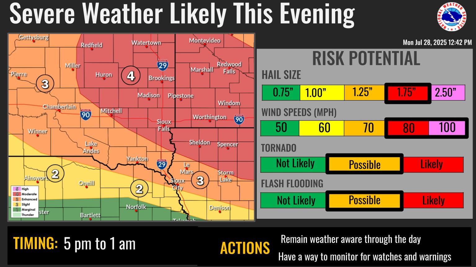
NWS Forecast: Wind, Hail, and Tornado Risks for Sioux Falls
The NWS highlighted the potential for wind gusts reaching 80 mph or greater in Sioux Falls, with a 45% chance of such winds. The agency also noted the risk of the system evolving into a derecho, a widespread, long-lived wind storm capable of producing hurricane-force wind speeds.
An extreme heat warning remained in effect through 8 p.m. on July 28, with heat indices exceeding 105 in some areas. This added another layer of risk, emphasizing the need for residents to stay hydrated and avoid strenuous outdoor activities.
There was a 15% chance of hail up to 1.5 inches in diameter and a 5% chance of tornadoes in the Sioux Falls area. Localized areas could also experience heavy downpours of 1-2 inches of rain, with isolated pockets up to 3 inches possible.
Conclusion: Staying Informed and Prepared
The severe storms that impacted Sioux Falls and surrounding areas on July 28, 2025, resulted in damage primarily to trees, power lines, and property. The National Weather Service played a critical role in providing timely warnings and updates, helping residents prepare for and respond to the severe weather.
Key takeaways from this event include the importance of monitoring weather alerts, taking immediate precautions when warnings are issued, and following the guidance of local authorities and emergency responders. Staying informed and prepared is essential for mitigating the risks associated with severe weather events.
As Sioux Falls moves forward, ongoing assessments and recovery efforts will be crucial in restoring normalcy and enhancing community resilience. FYM News will continue to provide updates on the situation, ensuring that residents have the information they need to stay safe and informed. The events of July 28 serve as a reminder of the power of nature and the importance of preparedness in the face of severe weather.
Leave a Reply