The Boston area is experiencing a welcome improvement in air quality after days of smoke from Canadian wildfires. While alerts remain for sensitive groups in some areas, the overall situation is getting better. Along with the improved air quality, residents can expect a cool down in temperatures. This article will cover the latest weather forecast, detailing the factors contributing to these changes and what to expect in the coming days.
Understanding the fluctuations in air quality and temperature is crucial for planning daily activities and protecting your health. We’ll break down the key points from Cindy Fitzgibbon, Chief Meteorologist, providing you with a clear picture of what’s happening in the skies above Boston.
Air Quality Improvement in Boston
Boston’s air quality is currently in the “moderate” range, indicated by yellow dots across Massachusetts. While this is an improvement from previous days, it is still unhealthy for sensitive groups. The smoke from the Canadian wildfires is thinning out, leading to better conditions. However, air quality alerts remain in effect for other parts of New England, including New Hampshire, Connecticut, and Vermont, until 11 PM.
Yesterday, the air quality was in the “dark orange and red” zones, indicating much thicker smoke. The shift to “moderate” is a positive step, but it’s essential to stay informed and take precautions if you are in a sensitive group. As Cindy Fitzgibbon noted, “It’s just a little better than it was yesterday.”
Cool Down and Onshore Winds
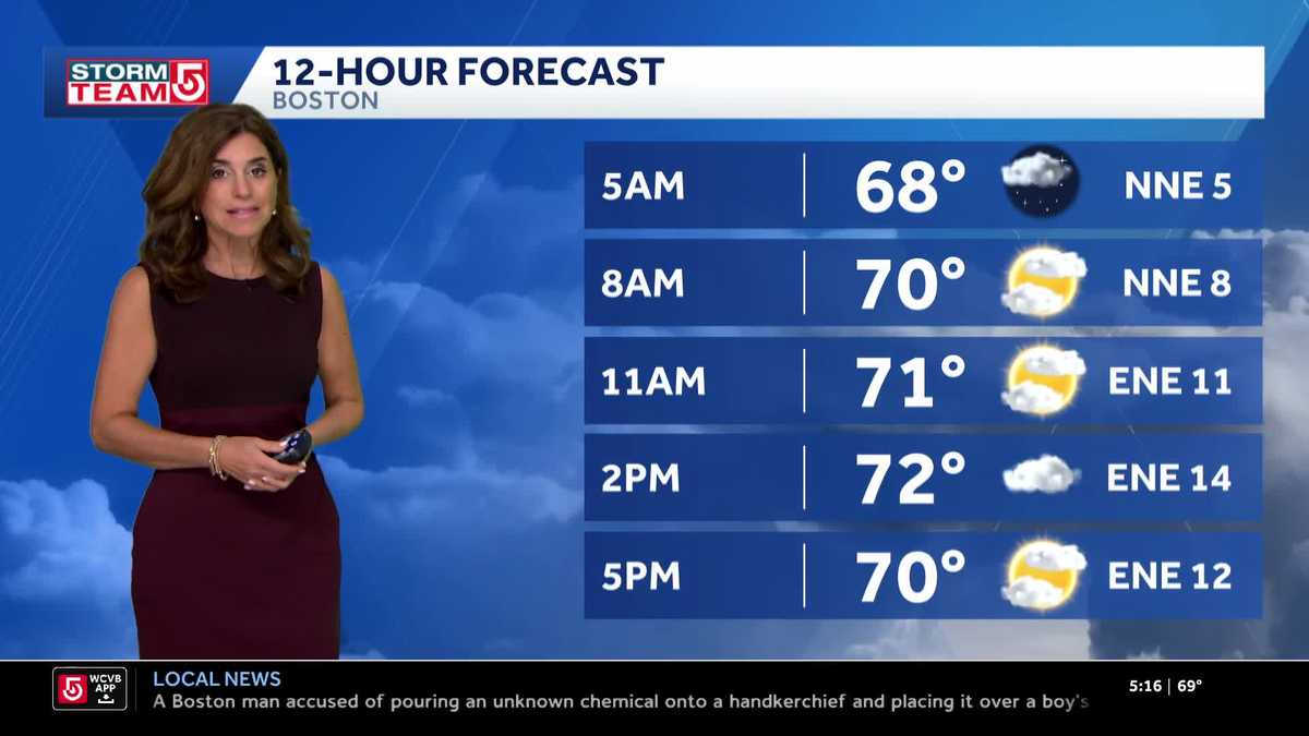
A Canadian high-pressure system is building in, bringing with it an east-northeasterly wind. This wind is helping to thin out the smoke and contributing to cooler temperatures, especially along the coast. Currently, temperatures are mainly in the 60s, with some areas near the Cape experiencing temperatures in the 50s. This provides a fairly comfortable start to the day.
The onshore wind will keep coastal areas cooler, with temperatures holding in the low 70s. Boston is expected to reach 73 degrees, while inland areas like Nashua and Worcester may touch 80 degrees. Further west, temperatures will be warmer. According to Fitzgibbon, “We’re running a little cooler today.”
Cloudiness and Potential Showers
In addition to the haze and smoke, there is cloudiness moving in due to a front dropping south. This front is described as a “wind shift line” and is not expected to bring significant moisture. However, it will contribute to extra clouds throughout the day. There is a slight chance of isolated showers in the western part of the state late in the day, but otherwise, skies will be mostly cloudy into tonight.
The cloud cover will help keep temperatures down, and overnight lows are expected to be in the upper 50s and lower 60s, making for comfortable sleeping conditions. As Fitzgibbon mentioned, “Not out of the question. Late in the day, a couple of isolated showers pop out in the western part of the state, but that would be the extent of it.”
Mid-Week Weather
Wednesday is expected to remain cooler, with temperatures staying in the 70s. Coastal areas will be in the low 70s, while inland areas reach the upper 70s. This is due to the continued east wind and mostly cloudy skies. Thursday should bring brighter conditions as the high-pressure system builds in further.
Fitzgibbon noted, “Wednesday. Not going to be all that warm. In fact, it’s a little bit cooler staying in the 70s tomorrow.” Expect partial sunshine again tomorrow, with conditions improving on Thursday.
Weekend Warm-Up
As we head into the weekend, temperatures are expected to rise. By Sunday, temperatures will be near 90 degrees, and this warm trend is likely to continue into early next week. The heat and humidity will return as the high-pressure system shifts.
Fitzgibbon stated, “Notice we’re near 90 on Sunday and we should be back around 90 again early next week. So nice.” Prepare for a significant warm-up as the weekend approaches.
Tropical Storm Update
Tropical Storm Dexter is currently moving into the North Atlantic and is not expected to affect the Boston area. However, the Hurricane Center is monitoring another wave near the coast with a 30% chance of developing in the next seven days. Additionally, a wave off the coast of Africa has a better chance of becoming the next named system.
Fitzgibbon assured viewers, “Still monitoring Tropical Storm Dexter here in the Atlantic, moving more into the North Atlantic. So this isn’t going to bother us.” While Dexter poses no threat, it’s essential to stay informed about potential future developments in the Atlantic.
In summary, Boston is experiencing improving air quality and a temporary cool down. The east-northeasterly wind and cloud cover are contributing to milder temperatures. While air quality alerts are still in effect for sensitive groups in some areas, the overall trend is positive. As we move into the weekend, expect a significant warm-up with temperatures nearing 90 degrees.
Stay tuned to FYM News for the latest updates on air quality and weather forecasts. Understanding these changes allows you to plan your activities and protect your health. Keep an eye on the skies, and enjoy the improved conditions while they last. Remember that the weather is ever-changing, and being prepared is key to navigating the elements.

Leave a Reply