Hurricane Erin, once a formidable Category 5 storm, has weakened to a Category 3 but remains a significant threat to the Caribbean and potentially the U.S. East Coast. This article provides the latest updates on Erin’s path, intensity, and potential impact, ensuring you stay informed and prepared. With strong winds and the potential for flooding and landslides, it’s crucial to monitor this evolving weather event.
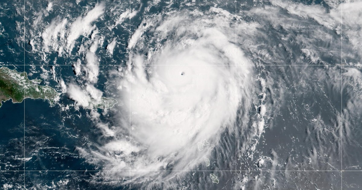
As of early Sunday morning, Hurricane Erin was located approximately 140 miles north of San Juan, Puerto Rico, moving west-northwest at 14 mph with maximum sustained winds of 125 mph. The storm is projected to curve north between the U.S. East Coast and Bermuda next week. While a direct landfall is not currently forecast, the hurricane’s effects are far-reaching, impacting islands with powerful waves and heavy rainfall.
This article will cover the current status of Hurricane Erin, areas under watch, the storm’s projected path, and the potential for life-threatening conditions. Stay tuned for detailed analysis and important safety information to help you navigate this hurricane season.
Hurricane Erin’s Current Status
As of the latest reports, Hurricane Erin is a Category 3 storm, with maximum sustained winds of 125 mph. The storm is moving west-northwest at 14 mph and is located about 140 miles north of San Juan, Puerto Rico. Despite the weakening from its earlier Category 5 status, Erin remains a major hurricane and poses a significant threat.
The National Hurricane Center (NHC) is closely monitoring the storm’s path and intensity. The latest forecasts indicate that Erin will curve north between the U.S. East Coast and Bermuda next week. However, even without making direct landfall, the storm is expected to generate large, powerful waves and heavy rainfall, impacting several regions.
Residents and visitors in the U.S. and British Virgin Islands, Puerto Rico, and the southeastern and central Bahamas are advised to monitor the storm closely. The NHC has issued warnings about potential flooding and landslides due to the strong winds and heavy rainfall associated with Hurricane Erin.
“Those in the U.S. and British Virgin Islands, Puerto Rico and the southeastern and central Bahamas should monitor the storm, the hurricane center said.”
Areas Under Hurricane and Tropical Storm Watch
Several areas are currently under hurricane and tropical storm watches as Hurricane Erin approaches. The Turks and Caicos Islands are under a tropical storm watch, meaning that tropical storm conditions are expected within the next 36 hours. Residents in these areas should prepare for strong winds, heavy rainfall, and potential flooding.
In Sint Maarten, the Dutch half of St. Martin, a tropical storm watch and a flood advisory are in effect. The Virgin Islands also have a flood watch in effect through Monday evening, according to the Government House. These watches indicate an elevated risk of hazardous weather conditions that could impact daily life and safety.
It’s crucial for residents in these areas to stay informed about the latest weather updates and heed the advice of local authorities. Preparing emergency kits, securing properties, and having evacuation plans in place are essential steps to mitigate the potential impacts of Hurricane Erin.
Hurricane Erin’s Projected Path and Intensity
The National Hurricane Center’s projections indicate that Hurricane Erin will continue on a west-northwest track before curving north between the U.S. East Coast and Bermuda. This path keeps the storm offshore, but its effects will still be felt across a wide area. The storm is expected to pass east of the Turks and Caicos Islands and the southeastern Bahamas on Sunday night and Monday.
While the forecast shows no direct landfall, the hurricane’s intensity and proximity to coastal areas will generate powerful waves and dangerous rip currents. The NHC expects Erin to remain a major hurricane — Category 3 or higher — through midweek, posing ongoing risks to marine and coastal environments.
“Fluctuations in intensity are expected over the next day or two due to inner-core structural changes,” the hurricane center said in an update at 2 a.m. Sunday. These fluctuations mean that the storm could either strengthen or weaken, making continuous monitoring essential.
Potential Impact on Coastal Areas
Even without making landfall, Hurricane Erin’s strong winds and powerful waves are expected to have a significant impact on coastal areas. The hurricane center forecasts that large, powerful waves will affect Hispaniola, Turks and Caicos, the Virgin Islands, Puerto Rico, and the northern Leeward Islands. These conditions can lead to life-threatening surf and rip currents.
Residents and visitors in these areas should avoid swimming and other water activities. Coastal flooding is also a concern, particularly during high tide. It’s important to secure boats and other marine equipment and to stay away from beaches and shorelines.
“These rough ocean conditions will likely cause life-threatening surf and rip currents,” the center said. The combination of high waves and strong winds can create extremely dangerous conditions, making it crucial to heed all warnings and advisories.
Situation in Puerto Rico
Puerto Rico has already experienced some of the effects of Hurricane Erin, with about 130,000 utility customers losing power on Saturday night. The National Weather Service office in San Juan issued an alert for nearly two-thirds of the island, predicting 50 mph winds and urging people to shelter in safe structures.
A U.S. buoy 170 nautical miles north-northeast of San Juan measured waves as high as 27 feet Saturday night, according to National Data Buoy Center data. These high waves are indicative of the powerful ocean conditions generated by Hurricane Erin.
Those in Leeward Islands, Puerto Rico and the Virgin Islands can expect heavy rainfall with the possibility of 2 to 4 inches, the hurricane center said. “Locally, considerable flash and urban flooding, along with landslides or mudslides, are possible,” the hurricane center said.
Historical Context of Hurricane Erin
Erin is the fifth named storm of the 2025 Atlantic hurricane season but the first to reach hurricane status. Hurricane season starts June 1 and ends Nov. 30. This year’s hurricane season is now the fourth consecutive season with a Category 5 hurricane. This highlights the increasing frequency and intensity of major hurricanes in recent years.
Colorado State University meteorologist Philip Klotzbach that Erin’s earlier minimum central pressure reading is the lowest measured in an Atlantic season hurricane on or before Aug. 16 since 1979. Lower pressure is associated with more powerful cyclones.
The storm is the only Category 5 hurricane on record to form this early in the hurricane season, and the only Category 5 observed outside the Gulf or Caribbean this early in the year. It is also the 11th Category 5 hurricane in the past decade.
Conclusion: Staying Safe During Hurricane Season
Hurricane Erin, despite weakening to a Category 3 storm, continues to pose a significant threat to coastal areas with strong winds, powerful waves, and the potential for flooding and landslides. Residents and visitors in the affected regions should stay informed about the latest weather updates and heed the advice of local authorities.
Preparing emergency kits, securing properties, and having evacuation plans in place are essential steps to mitigate the potential impacts of Hurricane Erin. Avoiding swimming and other water activities is crucial due to the life-threatening surf and rip currents.
This hurricane season serves as a reminder of the increasing frequency and intensity of major hurricanes. Staying prepared and informed is the best way to ensure safety and minimize the impact of these powerful weather events.
Leave a Reply