As summer progresses, New Hampshire residents should prepare for rapidly changing weather conditions. This article provides a detailed outlook on today’s storm forecasts, the approaching Hurricane Erin, and the anticipated cooler weather for the upcoming week. Staying informed is crucial for planning activities and ensuring safety.
The main points covered include:
- Thunderstorm chances for this afternoon
- Hurricane Erin’s potential impact on coastal areas
- A shift to cooler and more comfortable weather next week
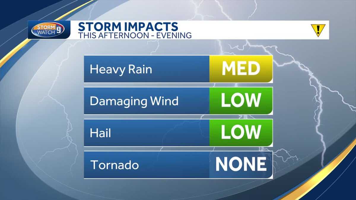
Afternoon Thunderstorms Expected
New Hampshire residents should brace for thunderstorms this afternoon. The combination of building heat and rising humidity creates an environment conducive to storm development. According to Matt Hoenig, meteorologist for WMUR, dew points have already increased to uncomfortable levels, hovering around the 60s this morning. These conditions will likely persist until a cold front brings relief later in the day.
The temperature could reach as high as 95 degrees in certain areas. Concord, Rochester, Manchester, and Nashua are all expected to experience scorching heat. Coastal regions like Portsmouth will be slightly cooler, with temperatures in the upper 80s. Northern areas of the state will see the arrival of showers and storms earlier, resulting in cooler temperatures.
Futurecast indicates patchy fog will dissipate in western zones, making way for sunshine. However, a front approaching from the north will bring clouds and showers to Coos County by midday. The remainder of the state should remain dry until around 2 p.m., after which thunderstorm activity will increase. Although not everyone is guaranteed rainfall, central parts of the state, including the Upper Valley and lakes region, are likely to see action around 4 or 5 p.m. Southern New Hampshire can expect storms to arrive between 5 and 7 p.m. Showers and downpours will gradually fade away after sunset.
While the threat of severe weather is low, there is a possibility of isolated strong storms with gusty winds or small hail. The primary concerns remain lightning and heavy downpours. Residents are advised to seek shelter indoors if they see lightning or hear thunder. The evening will bring cooler temperatures across the state, providing a welcome respite from the day’s heat and humidity.
Potential for a Record-Breaking Year
Concord has already recorded 24 days with temperatures reaching 90 degrees or higher this year. Today will likely mark the 25th such day, bringing the city closer to its record of 30 days set 70 years ago. With half of August still remaining, there is a chance to approach or even surpass this record. However, forecasts indicate that temperatures will trend cooler over the next seven days, potentially slowing the progression toward the record.
Hurricane Erin’s Trajectory and Impact
Hurricane Erin is currently a Category 3 hurricane passing north of the US and British Virgin Islands and Puerto Rico. The most intense weather is staying offshore, which is good news for these areas. Maximum winds have been recorded at 125 mph. Erin underwent rapid intensification yesterday, briefly becoming a Category 5 hurricane before weakening slightly due to wind shear.
The hurricane is expected to take a right-hand turn as it approaches Hispaniola and the Bahamas, largely avoiding land masses. This trajectory is favorable for the Caribbean islands. Erin will remain a powerful hurricane through today and tomorrow, eventually passing between the Carolinas and Bermuda by the middle of the work week.
Fortunately, Hurricane Erin is expected to steer clear of the east coast of the US. However, coastal areas in New Hampshire may experience rough surf and an increased risk of rip currents from Wednesday night into Friday. Marine interests should also be aware of potentially high seas. Inland impacts are not anticipated.
Cooler Weather on the Horizon
High pressure will dominate the weather pattern for the upcoming week, bringing plenty of sunny days. Temperatures are expected to remain below average, with highs in the 70s through Thursday. This cooler weather will provide a refreshing change after a hot summer. There is a chance of scattered showers on Wednesday, but otherwise, the week should remain mostly dry.
As the weekend approaches, temperatures are expected to rise again. However, the overall trend for the week is a welcome break from the heat. New Englanders can look forward to more comfortable conditions and relief from the humidity.
Key Takeaways
New Hampshire residents should stay informed about the changing weather conditions. This afternoon, expect thunderstorms with potential for isolated strong storms. Although Hurricane Erin will remain offshore, be mindful of rough surf and rip currents along coastal areas. The upcoming week will bring cooler temperatures and sunny skies, providing a much-needed break from the summer heat.
Staying updated with forecasts from WMUR and local meteorologists like Matt Hoenig is essential for planning activities and ensuring safety. Prepare for the storms today and enjoy the cooler weather next week. These insights help residents better prepare for the dynamic weather patterns in the region.
Leave a Reply