Here’s an article about Tropical Storm Warning Issued as Hurricane Erin Nears Outer Banks:
A potentially life-threatening situation is unfolding across the East Coast as Hurricane Erin approaches. Tropical Storm Warnings and Storm Surge Warnings have been issued for North Carolina’s Outer Banks, prompting evacuations and declarations of local states of emergency. While Hurricane Erin is not expected to make landfall in the United States, forecasters are concerned about the outer bands lashing the North Carolina coast with tropical-storm-force winds and heavy rain. Massive waves and dangerous rip currents add to the peril, urging officials to take decisive action to protect residents and visitors.
This article delves into the current warnings, evacuation orders, and potential impacts of Hurricane Erin on North Carolina’s Outer Banks and surrounding areas. We will explore the hurricane’s path, the specific threats it poses, and the measures being taken to ensure public safety. Stay informed and prepared as we navigate this developing weather event.
Tropical Storm and Storm Surge Warnings
The National Hurricane Center (NHC) has issued a Tropical Storm Warning for the area from Beaufort Inlet to Duck, North Carolina, and a Tropical Storm Watch is in effect from north of Duck to Cape Charles Light in Virginia. A Storm Surge Warning is also in place for the North Carolina Outer Banks from Cape Lookout to Duck. These warnings indicate that tropical-storm-force winds and dangerous storm surges are expected in these areas within the next 36 hours.
A tropical storm warning means that tropical storm conditions are expected somewhere within the specified area. In this case, residents and visitors in the Outer Banks should prepare for strong winds, heavy rainfall, and potential flooding. The storm surge warning indicates that there is a danger of life-threatening inundation from rising water moving inland from the coastline.
Mandatory Evacuations and States of Emergency
In response to the impending threat, officials in several North Carolina communities have issued mandatory evacuation orders and declared local states of emergency. Hyde County has declared a local state of emergency for Ocracoke Island, with a mandatory evacuation order in effect for visitors and residents. Dare County has also declared a state of emergency and ordered the evacuation of Hatteras Island, including the communities of Rodanthe, Waves, Salvo, Avon, Buxton, Frisco, and Hatteras.
These evacuation orders are in place to ensure the safety of residents and visitors in areas most vulnerable to the storm’s impacts. Evacuating early allows individuals to avoid hazardous conditions, such as flooded roads and downed power lines. It also enables emergency responders to focus on assisting those who are unable to evacuate themselves.
Threats from Winds, Waves, and Flooding
Hurricane Erin poses multiple threats to the Outer Banks, including tropical-storm-force winds, dangerous surf with waves of 15-20 feet, flooding of roads and neighborhoods, and rip currents. The combination of these factors creates a hazardous environment for anyone in the affected areas.
Even though Hurricane Erin is not expected to make landfall, the outer bands of the storm could still bring significant impacts to the coast. Strong winds can cause damage to property, including downed trees and power lines. Massive waves can erode beaches and coastal structures, while flooding can inundate homes and businesses. Rip currents are particularly dangerous for swimmers, as they can quickly pull individuals away from the shore.
Impacts Beyond North Carolina
The effects of Hurricane Erin are not limited to North Carolina. To the north in New Jersey, officials have prohibited swimming and other recreational water activities due to massive waves and life-threatening rip currents. Swimming, mobile sport fishing vehicle access, and other programs have been suspended at Island Beach State Park. In Wildwood, swimming is prohibited on all local beaches due to the dangerous surf conditions.
These restrictions highlight the widespread impact of Hurricane Erin, even in areas far from its center. The storm’s large size and powerful winds are generating dangerous conditions along much of the East Coast. Beachgoers are urged to heed all warnings and stay out of the water until the storm has passed and conditions have improved.
Hurricane Erin’s Current Status and Forecast
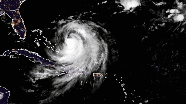
As of August 19, 2025, Hurricane Erin has maximum sustained winds of 105 mph with some higher gusts. The National Hurricane Center (NHC) said that some fluctuations in strength are possible over the next few days. The storm is located less than 700 miles to the south-southeast of Cape Hatteras, North Carolina, and is moving off to the northwest at 9 mph.
The NHC expects a turn toward the north-northwest with an increase in forward speed on Tuesday, followed by a northward motion on Wednesday and then a northeastward motion on Thursday. On that track, the center of Hurricane Erin is expected to pass to the east of the Bahamas on Tuesday and Tuesday night, and then move over the western Atlantic between the U.S. East Coast and Bermuda on Wednesday and Thursday.
Stay Informed and Stay Safe
Hurricane Erin poses a significant threat to North Carolina’s Outer Banks and surrounding areas. Tropical Storm and Storm Surge Warnings are in effect, and mandatory evacuation orders have been issued for several communities. Residents and visitors are urged to heed all warnings and follow the instructions of local emergency management officials.
Even though Hurricane Erin is not expected to make landfall, the outer bands of the storm could still bring significant impacts to the coast. Strong winds, massive waves, flooding, and dangerous rip currents all pose a threat. By staying informed and taking appropriate precautions, individuals can minimize their risk and ensure their safety during this weather event.
Leave a Reply