The Atlantic hurricane season is always a time of vigilance, and in 2025, all eyes are on Invest 98-L. The National Hurricane Center is closely monitoring this tropical system brewing in the Atlantic. Current forecasts suggest it has a high chance of developing into Tropical Storm Melissa. This article provides the latest maps, spaghetti models, and expert analysis to help you stay informed and prepared.
Understanding the potential path and intensity of Invest 98-L is crucial for residents in Florida, Texas, and the broader Caribbean region. We will break down the key information from the First Warning Weather team, led by Chief Meteorologist Tony Mainolfi, Eric Burris, Marquise Meda, and Cam Tran. This includes the possible formation of Tropical Storm Melissa and what it means for you.
Here’s what we’ll cover: the current status of Invest 98-L, analysis of spaghetti models, expert forecasts, and essential resources for hurricane preparedness. Stay tuned to FYM News for real-time updates and dependable insights as we navigate this developing weather event.
Current Status of Invest 98-L
As of October 21, 2025, Invest 98-L is a tropical system located in the Atlantic being closely monitored by the National Hurricane Center. The system is showing signs of organization and is expected to develop further. Meteorologist Eric Burris notes that it’s likely to become Tropical Storm Melissa soon. He also pointed out the presence of cold fronts and dry air pushes will act as an atmospheric brick wall, pushing the storm out to sea.
Hurricane Hunters are commencing missions today, starting at 12:45 PM, to gather critical data on Invest 98-L. This information will help refine the models and provide a more accurate forecast of the system’s future path and intensity.
Bookmark this page for continuous updates, including the latest maps and spaghetti models. Staying informed is your best defense against the unpredictable nature of tropical systems.
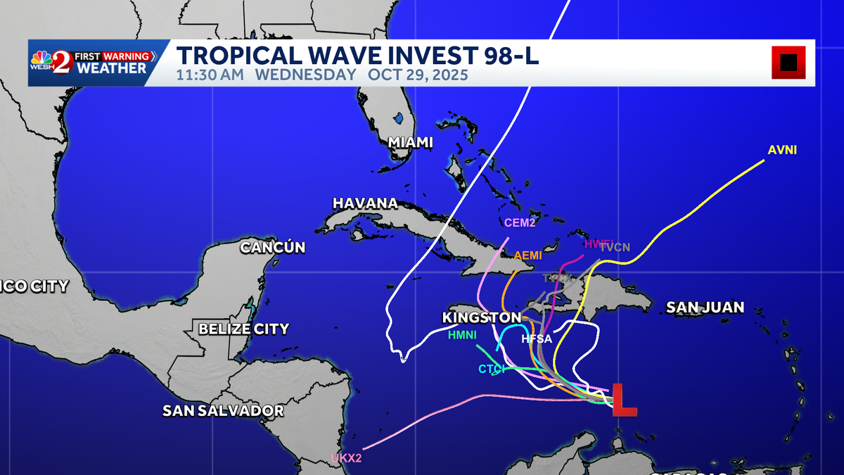
Understanding Spaghetti Models
Spaghetti models, also known as ensemble models, are a collection of different computer models that forecast the potential path of a tropical system. Each line on the map represents a different model’s prediction, and the clustering of these lines can give an idea of the most likely track. However, it’s important to remember that these are just predictions, and the actual path can vary.
The images provided show various storm models and potential paths for Invest 98-L. These models are updated frequently as new data becomes available, so it’s crucial to stay updated with the latest information. The First Warning Weather team uses these models to provide the most accurate forecast possible for Central Florida.
When interpreting spaghetti models, pay attention to the density of the lines. A tighter cluster suggests a higher confidence in that particular path, while a wider spread indicates more uncertainty. Always consider a range of possibilities when preparing for a potential storm.
Expert Forecasts and Analysis
The First Warning Weather team, including Chief Meteorologist Tony Mainolfi and meteorologists Eric Burris, Marquise Meda, and Cam Tran, are dedicated to providing the most accurate forecasts for Central Florida. Their analysis of Invest 98-L takes into account a variety of factors, including atmospheric conditions, sea surface temperatures, and historical data.
Eric Burris highlighted that despite the potential development of Tropical Storm Melissa, the storm’s ability to impact Florida directly is limited due to prevailing weather patterns. Cold fronts and pushes of dry air are expected to steer the storm away from the coast, effectively acting as an atmospheric barrier.
Stay tuned to WESH 2 online and on-air for the latest updates from the First Warning Weather team. Their expertise and continuous monitoring ensure you have the information you need to stay safe.
Hurricane Preparedness Guide
Even with forecasts indicating Invest 98-L may be pushed out to sea, it’s always essential to be prepared. The Atlantic hurricane season runs from June 1 through November 30, making it crucial to have a plan in place. Here are some key steps to ensure your safety:
- Create an Emergency Kit: Include essentials such as water, non-perishable food, medications, flashlights, batteries, and a first-aid kit.
- Develop an Evacuation Plan: Know your evacuation routes and have a designated meeting place for your family.
- Secure Your Home: Trim trees, secure loose outdoor items, and consider installing hurricane shutters.
- Stay Informed: Monitor local news and weather updates from trusted sources like FYM News and WESH 2.
For a comprehensive guide, refer to the 2025 Hurricane Survival Guide provided by WESH 2. Preparation is key to minimizing risks and ensuring your well-being during hurricane season.
Download the Very Local App
Stay connected with real-time news and weather updates by downloading the Very Local app. This free app provides access to Central Florida news and weather coverage from WESH 2, ensuring you have the latest information at your fingertips.
With the Very Local app, you can stream live news broadcasts, receive alerts about developing weather situations, and access a wealth of resources to help you stay informed and prepared. It’s an invaluable tool for navigating hurricane season and other emergencies.
Conclusion
As Invest 98-L continues to develop in the Atlantic, it’s important to stay informed and prepared. While current forecasts suggest the potential Tropical Storm Melissa may be steered away from Florida and Texas, vigilance is always necessary during hurricane season. The First Warning Weather team at WESH 2, along with resources like the Very Local app and the 2025 Hurricane Survival Guide, are invaluable tools for staying safe.
Key takeaways include the importance of monitoring expert forecasts, understanding spaghetti models, and having a comprehensive hurricane preparedness plan. By staying informed and taking proactive measures, you can minimize risks and protect yourself and your loved ones.
Continue to check FYM News for the latest updates on Invest 98-L and other developing weather events. Your safety and well-being are our top priorities, and we are committed to providing you with the information you need to navigate hurricane season with confidence.
Leave a Reply