Minnesota is bracing for a significant weather event on Monday, April 28, 2025, with a moderate risk of severe storms threatening the Twin Cities and much of central and southern Minnesota, extending into west central and southwestern Wisconsin. This rare setup demands preparedness and awareness. This article provides a detailed timeline of the expected storms and essential safety measures to help you stay safe.
The forecast includes the potential for tornadoes, large hail, damaging winds, and frequent lightning. With a two-part storm system expected, it’s crucial to understand the timing and intensity of each phase. Central and southern Minnesota, including the Twin Cities, faces the highest risk, urging residents to remain vigilant and prepared.
This comprehensive guide will outline the timeline of the storms, explain the risks involved, and provide actionable steps to ensure your safety and the safety of your loved ones. Knowing what to expect and how to react can significantly reduce the impact of these severe weather conditions.
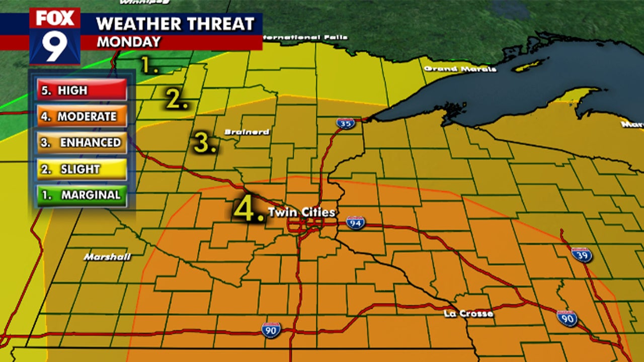
Moderate Risk of Severe Storms
A moderate risk, level four out of five for severe weather, indicates a high likelihood of widespread severe weather. Several tornadoes, large hail, damaging winds, and frequent lightning are possible. Residents need to stay informed and prepared.
The moderate risk designation underscores the seriousness of the impending weather conditions. It’s not just a typical thunderstorm; the atmosphere is primed for significant severe weather events. This means that the storms that develop could quickly become dangerous, with the potential for substantial damage.
Given the elevated risk level, it’s essential to have multiple ways to receive weather alerts and warnings. This includes the FOX 9 Weather app, local news broadcasts, and weather radios. Having access to real-time information will allow you to make informed decisions and take appropriate action when necessary.
Timeline of Possible Severe Storms
The severe weather event is expected in two rounds. The first round of storms will hit early in the morning, followed by a more potent second round in the late afternoon and early evening. Knowing the timeline helps in planning and preparedness.
The initial storms, expected between 4 a.m. and 9 a.m., may bring strong winds and large hail. While these storms can be dangerous, the atmosphere will destabilize further during the day, setting the stage for even more severe conditions later on.
The second round, from 5 p.m. to 10 p.m., poses the greatest threat, with all severe modes possible, including large hail, damaging winds, and tornadoes. The structure of these storms and the degree of sunshine will influence the tornado threat. Discrete supercells forming ahead of the main squall line could result in strong, intense tornadoes.
Understanding the Tornado Threat
The potential for tornadoes depends on storm structure. Discrete supercells can cause intense tornadoes, while linear storms may lead to weaker, short-lived tornadoes and straight-line winds. Understanding these differences is vital for assessing risk.
If individual supercell thunderstorms develop, they can rotate and produce strong, long-lived tornadoes. These types of storms are particularly dangerous and require immediate action if a warning is issued.
Conversely, if the storms quickly merge into a line, the tornado threat decreases, but the risk of damaging straight-line winds increases. These winds can cause widespread damage and are still a significant hazard.
How to Prepare for Severe Storms
Preparation is key to safety. Develop a severe weather safety plan, ensure you can receive warnings, review safe shelter locations, and establish a communication plan with family and friends. These steps can save lives.
Your safety plan should include a designated safe room or area in your home, such as a basement or interior room on the lowest level. It’s also important to have a supply kit with essential items like water, food, a flashlight, and a first-aid kit.
Staying connected with family and friends is crucial during a weather emergency. Make sure everyone knows where to go and how to communicate if separated. Designate a meeting point outside of your immediate neighborhood in case you can’t return home.
City of Minneapolis Warning
Minneapolis city officials urge residents to be weather-aware and take precautions. They emphasize the likelihood of tornadoes, large hail, damaging winds, and frequent lightning. Following their tips can enhance safety.
City officials recommend having access to weather alerts, being ready to take shelter in a basement or interior room, securing outdoor furniture, clearing leaves from catch basins, and preparing for potential power outages.
These measures are designed to minimize the impact of the storms and protect residents from injury or property damage. By taking these steps, you can help ensure the safety of yourself and your community.
Conclusion: Staying Safe During Severe Weather
The upcoming severe storms pose a significant threat to Minnesota. Stay informed, prepare a safety plan, and heed warnings from officials and meteorologists. Your safety depends on your preparedness and response.
Key takeaways include understanding the timeline of the storms, recognizing the potential for tornadoes and damaging winds, and having a well-defined safety plan. Staying connected and informed is crucial for making timely decisions.
The impact of severe weather can be minimized through proactive measures. By following the guidelines outlined in this article, you can help ensure the safety and well-being of yourself, your family, and your community. Stay vigilant, stay informed, and stay safe.
Leave a Reply