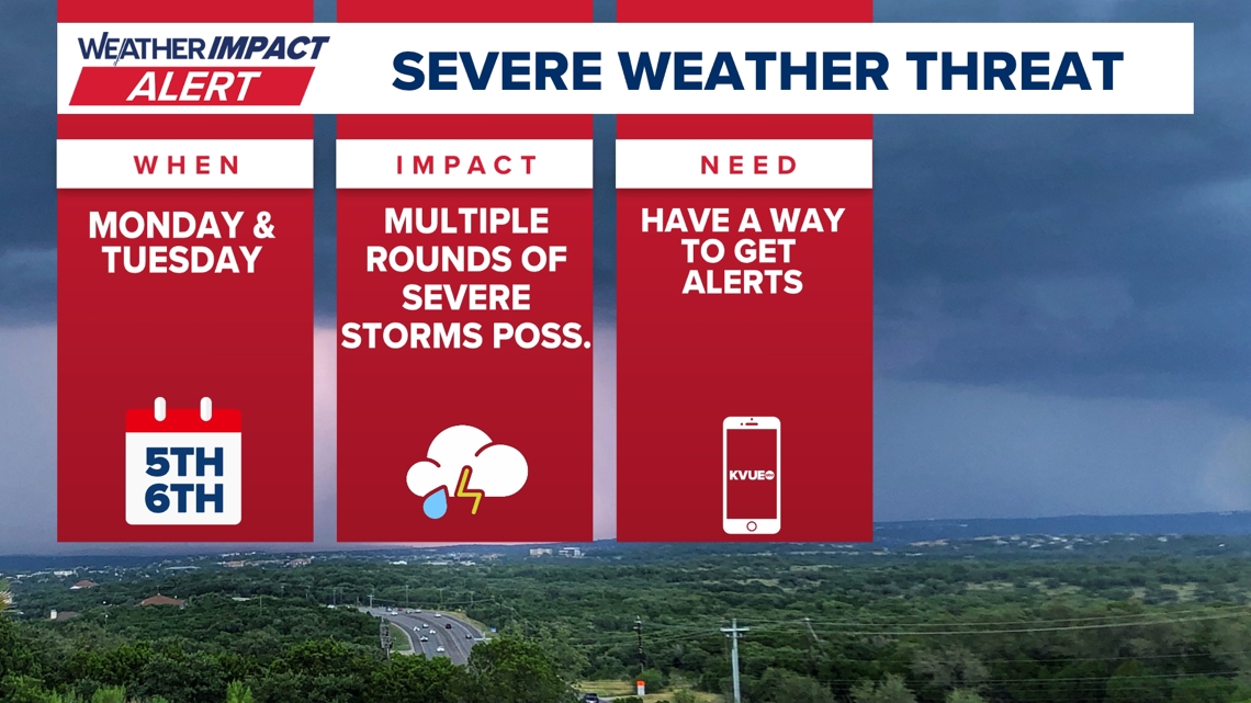
Severe Storms Threaten Central Texas: Tornado Watch Issued
Central Texas residents are bracing for a day of severe weather as the KVUE Weather Team has issued a Weather Impact Alert. A tornado watch is in effect for all Central Texas counties until 4 p.m. Tuesday, May 6, urging residents to stay informed and prepared. Multiple rounds of storms are anticipated, bringing the potential for large hail, isolated tornadoes, and flooding. Understanding the timing and primary threats is crucial for ensuring safety during this period of heightened weather activity.
This article provides a comprehensive overview of the expected weather conditions, offering insights into the timing of the storms, the areas most likely to be affected, and the necessary precautions to take. Stay tuned for the latest updates and ensure you’re prepared for any potential severe weather impacts.
Timing and Primary Threats
The National Weather Service has issued a tornado watch for all Central Texas counties, effective until 4 p.m. Tuesday. High-resolution model guidance indicates that strong to severe storms could impact the Interstate 35 corridor and the Austin metro area during the morning commute, generally between 6 a.m. and 9 a.m. Be prepared for hazardous driving conditions and potential delays.
The primary threats associated with these storms include large hail, damaging winds, isolated tornadoes, and heavy rainfall. Not everyone will experience severe weather, but it’s essential to be prepared for storms that could turn severe. The overall storm chance for Tuesday is approximately 70%, so stay vigilant and monitor weather updates.
Impact on Morning Commute
The potential for severe storms during the Tuesday morning commute poses a significant risk to drivers. The KVUE Weather Team advises motorists to exercise caution and allow extra travel time. Stay tuned to local news and weather updates for the latest information on road closures and hazardous conditions.
If you encounter severe weather while driving, pull over to a safe location away from trees and power lines. Stay in your vehicle and turn on your hazard lights. Avoid driving through flooded areas, as flash flooding can occur rapidly. Your safety is the top priority, so be prepared to adjust your route or delay your commute if necessary.
Afternoon and Evening Severe Weather Outlook
A cold front is expected to push through the KVUE area during the afternoon and evening, potentially triggering another round of severe weather late Tuesday. The development of this second round remains uncertain and will depend on atmospheric conditions. If instability builds back in, isolated supercells may redevelop, particularly east of I-35.
These supercells could bring all types of severe weather, including large hail, damaging winds, and isolated tornadoes. The KVUE Weather Team will continue to monitor the situation closely and provide updates as new information becomes available. Stay informed and be prepared for the possibility of additional severe weather throughout the day.
Extended Forecast: Drier Conditions Ahead
After Tuesday’s severe weather threat, a few lingering storms are possible on Wednesday. However, the forecast trends drier and quieter into late week and the weekend. This respite from severe weather will provide an opportunity for residents to recover and prepare for any future weather events.
The KVUE Weather Team will continue to monitor the evolving forecast and provide updates as needed. Stay tuned to KVUE for the latest information on weather conditions and any potential impacts on your area.
Staying Informed and Prepared
Staying informed is the best way to protect yourself and your family during severe weather. The KVUE Weather Team encourages residents to monitor local news and weather updates regularly. Download the KVUE app for the latest forecasts, radar images, and severe weather alerts.
In addition to staying informed, it’s essential to have a plan in place in case severe weather strikes. Designate a safe room in your home where you can take shelter during a tornado or other severe weather event. Have a supply kit on hand with essentials such as water, food, and a flashlight. By taking these steps, you can minimize the impact of severe weather on your life.
Conclusion: Staying Safe During Severe Weather
Central Texas faces a significant threat of severe weather on Tuesday, May 6, with a tornado watch in effect until 4 p.m. The KVUE Weather Team urges residents to stay informed, be prepared, and take necessary precautions to protect themselves and their families. The timing of the storms, particularly during the morning commute, poses a risk to drivers, so exercise caution and allow extra travel time.
The potential for large hail, damaging winds, isolated tornadoes, and heavy rainfall underscores the importance of staying vigilant and monitoring weather updates. While the forecast trends drier and quieter into late week, the immediate threat requires immediate attention and preparedness. Stay tuned to KVUE for the latest information and ensure you’re ready to respond to any severe weather impacts.
Leave a Reply