A devastating storm system swept through St. Louis on Friday, leaving a trail of destruction and claiming the lives of at least four people. The event underscores the increasing intensity and frequency of severe weather events across the United States. Millions remain under threat as the same system continues to unleash powerful tornadoes and violent winds across the eastern half of the country. This article provides the latest updates on the St. Louis tragedy, tracks the ongoing severe weather outbreak, and offers guidance on how to stay safe.
The situation in St. Louis is critical, with local authorities working to assist the injured and assess the full extent of the damage. Meanwhile, weather experts warn of continued risks, including the potential for long-track tornadoes and hurricane-force wind gusts. In this article, we will cover the immediate aftermath of the St. Louis tornado, analyze the broader severe weather patterns, and provide essential information on using tornado radar to stay informed and protected.
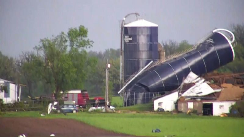
St. Louis Reels from Deadly Tornado
The tornado that struck the St. Louis area Friday afternoon resulted in at least four fatalities and numerous injuries. St. Louis Mayor Cara Spencer confirmed the deaths during a news conference, highlighting the immediate need for rescue and relief efforts. Ten patients are currently receiving treatment at St. Louis’ Children’s Hospital, with one in critical condition, according to hospital spokesperson Laura High. The focus remains on providing medical assistance and supporting affected families.
The St. Louis Metropolitan Police Department has reported widespread damage throughout the city. An “extremely dangerous tornado” tracked through the region, as described by the National Weather Service, leaving many residents displaced and essential infrastructure compromised. Over 100,000 customers in Missouri, primarily in the eastern part of the state, are without power, according to PowerOutage.us. The scale of the damage underscores the severity of the storm and the challenges ahead in recovery.
“We are aware of damage throughout the City,” stated the St. Louis Metropolitan Police Department, emphasizing the extensive impact of the tornado.
Severe Weather Outbreak: Millions Under Threat
The St. Louis tornado is part of a larger, multi-day severe weather outbreak affecting a vast area of the United States. Nearly 9 million people from Missouri to Kentucky are under a level 4-of-5 risk of severe thunderstorms, with potential for extensive wind damage, large hail, and tornadoes. The Storm Prediction Center (SPC) has warned that “several strong tornadoes are expected and a long-track, high-end tornado will be possible,” highlighting the extreme danger.
Friday’s storms are forming in an “exceptionally volatile environment,” according to the National Weather Service in Paducah, Kentucky. These storms have the potential to produce widespread damaging wind gusts exceeding 75 mph, starting in the early evening. The SPC emphasizes that some areas in the path of the storms could experience “intense supercells,” further elevating the risk. Residents are urged to remain vigilant and take necessary precautions.
Widespread Damage Across the Midwest
The severe weather outbreak has already left a significant mark across the Midwest. On Thursday, at least 11 tornadoes were reported in Minnesota, Wisconsin, Illinois, and Michigan, leaving nearly 400,000 homes and businesses without power. Communities are grappling with the aftermath as they assess the damage and work to restore essential services. Wisconsin’s Dodge County was particularly hard-hit, with significant damage reported and at least one person hospitalized with injuries.
Sheriff Dale Schmidt of Dodge County reported that many streets and highways are closed due to downed power lines and trees. Multiple homes in Juneau were damaged, with at least one house suffering a roof collapse. Fortunately, everyone inside was able to escape safely. The situation underscores the need for robust emergency response systems and community preparedness.
Tracking Tornadoes with Radar Technology
Tornado radar is an indispensable tool for tracking severe weather and providing timely warnings. Modern radar systems can detect the formation and movement of tornadoes, allowing meteorologists to issue alerts and give residents crucial time to seek shelter. Features like the “hook echo” are telltale signs of a potential tornado, enabling forecasters to make informed decisions and save lives.
Several resources are available for real-time tornado tracking. The National Weather Service provides up-to-date radar information, and numerous apps and websites offer detailed weather data. Staying informed through these channels can significantly enhance personal safety during severe weather events. It’s essential to understand how to interpret radar images and heed warnings issued by local authorities.
Continued Risks and Future Outlook
The severe weather threat extends beyond the Midwest, with damaging storm risks persisting for days. On Saturday, severe thunderstorms are possible in the Mid-Atlantic and Northeast as the same storm system pushes east. Damaging wind gusts and hail are the primary concerns, but tornadoes cannot be ruled out. Residents in these areas should stay informed and prepared for potential disruptions.
New storms could also bring damaging wind gusts, hail, and tornadoes to parts of the southern Plains, starting Saturday afternoon. The Plains will remain the main focus of severe weather on Sunday and Monday, with damaging storms possible in much of Oklahoma and Kansas. The severe thunderstorm threat will then shift back into parts of the Mississippi Valley on Tuesday. Monitoring these evolving patterns is crucial for effective preparedness.
Safety Measures and Preparedness
Given the ongoing severe weather risks, it is vital to take proactive safety measures. Create an emergency plan that includes a designated safe room, a supply kit with essential items, and a communication strategy to stay in touch with family members. Stay informed by monitoring local news, weather alerts, and tornado radar updates. When a tornado warning is issued, seek shelter immediately in a basement, storm cellar, or interior room on the lowest floor of a sturdy building.
During a severe thunderstorm, avoid windows and doors, and stay away from electrical equipment and plumbing. If you are outdoors, find shelter in a low-lying area away from trees and power lines. Remember that nighttime tornadoes are particularly dangerous, as they are harder to see and can catch people off guard. Always have a reliable source of weather information and heed warnings issued by local authorities.
Conclusion: Staying Informed and Prepared
The recent tornado in St. Louis serves as a stark reminder of the destructive power of severe weather and the importance of preparedness. As millions remain under threat from ongoing storms, staying informed, taking proactive safety measures, and utilizing tools like tornado radar are essential for protecting lives and minimizing damage. The situation requires vigilance, community cooperation, and a commitment to resilience in the face of increasing environmental challenges.
The multi-day severe weather outbreak underscores the need for continued research, improved forecasting, and enhanced public awareness. By learning from these events and investing in better preparedness strategies, communities can mitigate the impacts of future storms and build a safer, more resilient future. The events in St. Louis and across the Midwest highlight the collective responsibility to address the growing threat of severe weather and protect vulnerable populations.
Leave a Reply