New Orleans is no stranger to heavy rainfall, and recent weather patterns have prompted concerns about potential flooding. A flood advisory has been issued for parts of Jefferson, Orleans, and Plaquemines Parishes, leaving residents wondering how much rain to expect and when the advisory will end. This article provides up-to-date information and practical advice to help you stay safe and prepared.
Understanding the timing and intensity of rainfall is crucial for mitigating flood risks. We’ll delve into the details of the current flood advisory, offering insights from local meteorologists and emergency management officials. Furthermore, we’ll explore preventative measures you can take to protect your property and ensure your safety during this weather event.
In this comprehensive guide, we’ll cover:
- The specific areas under the flood advisory
- Expected rainfall amounts and duration
- Practical steps to clean your catch basin
- Actions to take if flooding occurs
- Accessing real-time radar and weather alerts
Current Flood Advisory Details
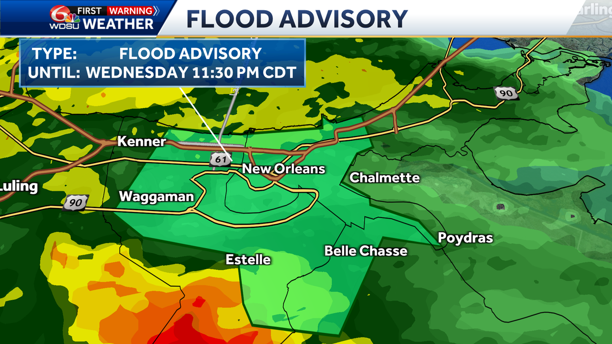
As of May 28, 2025, a flood advisory is in effect for parts of Jefferson, Orleans, and Plaquemines Parishes until 11:30 p.m. CDT. This advisory was issued due to concerns over another round of heavy rain potentially causing further flooding in the Greater New Orleans area. Meteorologist Devon Lucie from WDSU reports that the region has already experienced significant rainfall, with some areas receiving close to four inches.
The National Weather Service has indicated that additional rainfall of 1 to 2.5 inches is possible, which could exacerbate existing flooding conditions. Residents are urged to stay vigilant and take necessary precautions to protect themselves and their property.
Key points to consider during this advisory:
- Affected Areas: Jefferson, Orleans, and Plaquemines Parishes
- Advisory End Time: 11:30 p.m. CDT, May 28, 2025
- Expected Rainfall: 1 to 2.5 inches
Devon Lucie noted, “We still have another round of storms to come through… It’s not moving too fast eastward… Those that if they would be here, they’re not going to arrive closer to about 8 to 10:00 here tonight.” This slow-moving system means prolonged periods of heavy rain, increasing the risk of flooding.
Rainfall Totals and Impact
The New Orleans metropolitan area has seen varied rainfall totals, with some areas experiencing up to four inches of rain. According to WDSU’s weather updates, the heaviest rainfall has been concentrated in the North Shore region and parts of the West Bank near Thibodaux. River Parishes have also received a significant amount of rain, contributing to the overall flood risk.
Live Doppler radar imagery shows persistent heavy downpours across the region. Although the storms aren’t classified as severe, they’re close to severe levels, prompting special weather statements. These conditions can lead to rapid water accumulation and potential flash flooding.
Rainfall amounts from different areas:
- North Shore: Close to 4 inches
- West Bank (near Thibodaux): Significant rainfall
- River Parishes: Substantial rainfall
As Devon Lucie mentioned, “We’ve had quite a bit of rain here in New Orleans. Other areas have gotten it too, but not everyone… There’s some heavy downpours and pockets of it here.” This uneven distribution highlights the importance of staying updated with local weather alerts.
Preparing for More Storms
The forecast indicates that additional storms are expected to move through the New Orleans area. These storms are predicted to arrive between 8 and 10 p.m. CDT and may bring heavy downpours and gusty winds. It’s essential to take proactive steps to minimize potential flood damage.
Here are some measures you can take to prepare for the upcoming storms:
- Secure Outdoor Items: Bring in loose objects such as patio furniture, garbage cans, and decorations.
- Check Gutters and Drains: Ensure that gutters and drains are clear of debris to allow for proper water runoff.
- Monitor Weather Alerts: Stay informed about the latest weather updates and warnings from local news sources and the National Weather Service.
- Prepare an Emergency Kit: Gather essential supplies such as water, non-perishable food, flashlights, and a first-aid kit.
According to Lucie, “We still keep storms through 8 to 10:00 here tonight, right on the timing from the west to east, movement of storms I just showed and we still have a chance of some scattered storms overnight towards tomorrow morning.” Prepare for a wet and stormy night and morning.
How to Clean Your Catch Basin
One of the most effective ways to prevent street flooding is by regularly cleaning your catch basin. Catch basins are the drains located on the street that collect rainwater and direct it into the sewer system. When these basins are clogged with leaves, trash, and other debris, they can’t effectively do their job, leading to water buildup and flooding.
Follow these steps to clean your catch basin:
- Gather Your Supplies: You’ll need gloves, a rake or grabber tool, a bucket, and a trash bag.
- Clear Surface Debris: Use the rake or grabber tool to remove any large items like leaves, branches, and trash from the surface of the catch basin.
- Remove Debris from the Basin: Carefully reach into the basin (wearing gloves) and remove any accumulated debris. Place the debris in your bucket and then transfer it to the trash bag.
- Flush the Basin: If possible, use a hose to flush out any remaining sediment or small debris from the basin.
- Dispose of Debris Properly: Tie up the trash bag securely and dispose of it according to your local waste management guidelines.
Regular maintenance of catch basins can significantly reduce the risk of street flooding in your neighborhood.
What to Do If It Floods
Despite your best efforts to prepare, flooding can still occur. Knowing how to respond safely and effectively is crucial. Here are some essential steps to take if flooding occurs:
- Stay Informed: Monitor local news and weather alerts for updates on the flooding situation.
- Avoid Walking or Driving Through Floodwaters: Floodwaters can be deeper and more dangerous than they appear. Additionally, they may contain hidden hazards such as debris, chemicals, and electrical wires.
- Turn Off Electricity: If it’s safe to do so, turn off the electricity at the main breaker to prevent electrical shocks.
- Evacuate If Necessary: If local authorities issue an evacuation order, follow their instructions and evacuate to a safe location.
- Document Damage: Take photos and videos of any flood damage for insurance purposes.
Remember, your safety is the top priority. Do not take unnecessary risks during a flood.
Accessing Real-Time Weather Updates
Staying informed about the latest weather conditions is crucial during a flood advisory. Here are some resources you can use to access real-time weather updates:
- WDSU First Warning Weather: Tune into WDSU for live weather coverage and updates from meteorologists like Devon Lucie.
- National Weather Service (NWS): Visit the NWS website for detailed forecasts, radar imagery, and weather alerts.
- Weather Apps: Download weather apps on your smartphone for instant access to weather information.
- Social Media: Follow local news channels and weather experts on social media for real-time updates and warnings.
By staying informed, you can make timely decisions to protect yourself and your property.
Conclusion
The flood advisory in Jefferson, Orleans, and Plaquemines Parishes serves as a reminder of the importance of preparedness and vigilance. By staying informed about weather conditions, taking proactive steps to protect your property, and knowing how to respond during a flood, you can minimize the impact of these events.
Key takeaways from this article include:
- A flood advisory is in effect until 11:30 p.m. CDT on May 28, 2025.
- Additional rainfall of 1 to 2.5 inches is possible.
- Cleaning your catch basin can help prevent street flooding.
- Knowing what to do during a flood is crucial for your safety.
Remember to monitor local weather updates and stay safe during this weather impact day. With the right preparation and knowledge, you can navigate these challenges effectively.
Leave a Reply