Mexico is on alert! This Thursday, several states are preparing for significant rainfall as a cold front sweeps across the country. Among those potentially affected is Hidalgo, where residents should stay informed and take necessary precautions. FYM News brings you the latest on this developing weather situation, ensuring you have the information to keep yourself and your loved ones safe.
The approaching cold front, combined with a mass of air, is set to unleash heavy downpours across Veracruz, Oaxaca, and Chiapas, with potential impacts reaching as far as Hidalgo. In addition to the rain, strong winds and cooler temperatures are expected. This article will delve into the specifics of the expected weather patterns, providing a detailed breakdown of the regions at risk and offering practical advice on how to prepare for these conditions.
Stay with FYM News as we explore the projected rainfall amounts, wind speeds, and temperature drops. We’ll also examine potential impacts on daily life and offer guidance on minimizing risks during this period of inclement weather. Knowledge is power, and we’re here to empower you with the information you need to navigate this weather event safely.
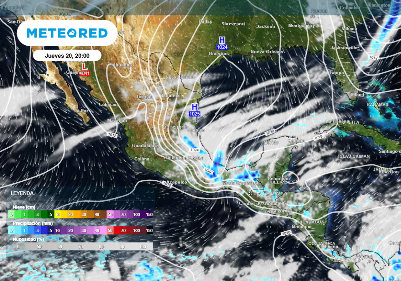
This Thursday, Mexico is bracing for the impact of a cold front, specifically Front 36, and the associated air mass driving it. The system is forecasted to move across the central, eastern, and southeastern regions of Mexico, eventually heading towards the Yucatan Peninsula later in the week. This weather pattern is expected to generate significant rainfall and strong winds across multiple states, potentially impacting daily life and requiring residents to take precautionary measures.
The most significant effect of this weather system is the likelihood of heavy rainfall. Certain regions are predicted to experience localized intense downpours, ranging from 50 mm to 75 mm. Veracruz, Oaxaca, and Chiapas are currently identified as the states most likely to be impacted by these heavy rains. Residents in these areas should be prepared for potential flooding and disruptions to daily routines. It’s essential to monitor local weather updates and heed any warnings issued by authorities.
In addition to the rainfall, a “Norte” event is anticipated, bringing very strong to intense winds to parts of eastern Mexico and the coasts of the Gulf of Mexico. Wind gusts are predicted to range from 80 to 100 km/h in these areas. As the week progresses, these strong winds are expected to extend towards the Yucatan Peninsula, potentially causing further disruptions and hazards. Residents should secure loose objects and avoid unnecessary travel during periods of high winds.
The primary regions facing the brunt of this weather system include Veracruz, Oaxaca, and Chiapas, where heavy rainfall is anticipated. These states should be prepared for potential flooding, landslides, and disruptions to transportation. Residents are advised to monitor local weather forecasts closely and follow any safety guidelines issued by local authorities. It’s also important to ensure that drainage systems are clear and functioning properly to minimize the risk of water damage.
Beyond the immediate impact zone, other states will also experience varying degrees of adverse weather conditions. Tabasco is expected to receive heavy showers with localized rainfall of up to 50 mm. Hidalgo, Puebla, the State of Mexico, and Campeche are predicted to have showers ranging from 5 to 25 mm. Even states like San Luis Potosi, Guanajuato, Queretaro, Mexico City, Yucatan, and Quintana Roo may experience isolated showers, although the intensity is expected to be lower.
The Isthmus and Gulf of Tehuantepec are also under a wind advisory, with gusts potentially reaching up to 100 km/h. Additionally, a “Tehuantepec event” is expected, further exacerbating wind conditions in the region. The combination of strong winds and heavy rainfall could lead to hazardous conditions for maritime activities and coastal communities. It is crucial for residents and visitors in these regions to stay informed and take necessary precautions to ensure their safety.
Strong winds are a significant component of this weather system. The Isthmus and Gulf of Tehuantepec are expected to experience winds of up to 60 km/h with gusts reaching 100 km/h. Veracruz is also under a “Norte” advisory, with winds potentially reaching 50 km/h and gusts ranging from 70 to 90 km/h. These strong winds can pose a threat to infrastructure, power lines, and transportation systems.
Tamaulipas is forecasted to have winds of up to 40 km/h with gusts between 60 and 80 km/h. Tabasco, Campeche, Yucatan, and Quintana Roo may experience winds of up to 30 km/h with gusts ranging from 50 to 70 km/h. These strong winds can cause choppy waters along the coast and make maritime activities dangerous. It’s essential to heed any warnings issued by maritime authorities and avoid boating or swimming during periods of high winds.
The influence of the air mass is predicted to extend as far north as Chihuahua, Durango, Coahuila, Nuevo Leon, San Luis Potosi, and Zacatecas. These areas may experience winds of up to 40 km/h with gusts between 60 and 80 km/h, potentially leading to dust storms and whirlwinds. Additionally, the Gulf of California is expected to have winds between 20 and 30 km/h with gusts of 50 to 70 km/h, causing waves up to 3 meters high. Residents in these regions should secure loose objects and take precautions to avoid potential hazards associated with strong winds.
During periods of heavy rainfall, it’s crucial to take necessary safety precautions to minimize the risk of accidents and injuries. Avoid driving through flooded areas, as even shallow water can be dangerous. If you encounter a flooded roadway, turn around and find an alternate route. Be aware of the potential for flash floods, especially in low-lying areas or near rivers and streams. Monitor local weather reports and heed any warnings issued by authorities.
Strong winds can also pose a significant threat. Secure any loose objects around your home or business, such as outdoor furniture, signs, or construction materials. Trim trees and branches that could potentially fall and cause damage. Avoid walking or driving under power lines during periods of high winds. If you live in a coastal area, be aware of the potential for storm surges and coastal flooding.
In addition to these general safety guidelines, it’s essential to have an emergency plan in place. Assemble a disaster preparedness kit that includes essential supplies such as food, water, medication, and a first-aid kit. Identify a safe place to shelter during severe weather events, and make sure everyone in your household knows the plan. By taking these precautions, you can significantly reduce the risk of injury or property damage during periods of inclement weather.
Staying informed is crucial during severe weather events. Monitor local news and weather reports for the latest updates and warnings. Pay attention to any advisories or alerts issued by local authorities. Use social media and weather apps to stay connected and receive timely information. Share important updates with your friends, family, and neighbors to help ensure everyone is aware of the potential risks.
FYM News is committed to providing you with the most up-to-date and accurate information possible. We will continue to monitor this weather system closely and provide regular updates as the situation evolves. Check our website and social media channels for the latest news and forecasts. By staying informed, you can make informed decisions and take the necessary steps to protect yourself and your loved ones.
Remember, preparation and awareness are key to staying safe during severe weather events. By taking the necessary precautions and staying informed, you can minimize the risks and ensure the safety of yourself and your community. FYM News is here to help you navigate these challenging times, providing you with the information and resources you need to stay safe and informed.
As Mexico prepares for the impact of Cold Front 36, it’s essential to stay informed and take necessary precautions. Heavy rainfall, strong winds, and cooler temperatures are expected across various states, potentially disrupting daily life and posing safety risks. Regions like Veracruz, Oaxaca, and Chiapas are particularly vulnerable to heavy rainfall, while the Isthmus and Gulf of Tehuantepec face the threat of high winds.
Residents in affected areas should closely monitor weather forecasts, heed warnings issued by authorities, and take proactive steps to protect themselves and their property. Securing loose objects, avoiding flooded roadways, and having an emergency plan in place are crucial measures to minimize potential risks. FYM News will continue to provide updates and information to help you stay informed and prepared.
Remember, severe weather events can be unpredictable, so it’s always best to err on the side of caution. Stay connected with your community, share information, and support each other during challenging times. By working together and staying informed, we can navigate these weather events safely and minimize the impact on our lives. FYM News is committed to serving as a reliable source of information and support throughout this period.
Leave a Reply