A significant weather event is unfolding across Maryland, with the potential for severe storms, including damaging winds and possible tornadoes. Residents are urged to stay alert and prepared as conditions can change rapidly. This comprehensive article provides up-to-date information on the developing situation, offering insights into the timing, potential impacts, and necessary precautions. Stay tuned to FYM News for real-time updates and expert analysis as we navigate this weather alert day together.
Understanding the dynamics of these storms is crucial for ensuring your safety and minimizing potential damage. We’ll delve into the factors contributing to the storm’s intensity, including the combination of hot, humid air and an approaching cold front. By staying informed and taking proactive measures, you can protect yourself, your family, and your property. This article aims to be your go-to resource for navigating this severe weather event in Maryland.
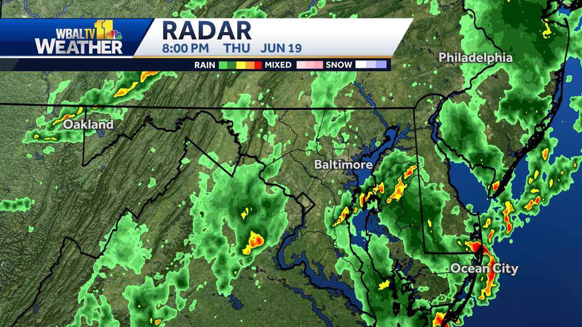
Current Weather Situation in Maryland
As of Thursday afternoon, the first line of strong storms has already moved through Maryland, bringing very strong wind gusts. A second line of showers is expected later in the evening, potentially bringing more strong to locally damaging wind gusts, especially in the mountains and Central Maryland. According to the rain gauge at Baltimore’s official weather-recording station, 0.43 inches of rainfall had been captured as of 5:45 p.m. Additionally, wind gusts of upwards of 55 mph were recorded across the Baltimore area.
Baltimore Gas and Electric (BGE) reported approximately 51,000 customer outages due to the storms, primarily affecting Anne Arundel and Prince George’s counties. The storms are rolling across the Eastern Shore counties, bringing wind gusts over 60 mph and heavy rain. The worst of the storms have moved east of the Baltimore metro area; however, many lightning strikes are still being detected. Be cautious and stay indoors if possible.
The Maryland Transit Administration reported that MARC Camden Line service was suspended due to multiple trees across the tracks. Severe thunderstorms are moving into Baltimore City, with damaging winds and dangerous lightning expected to reach Annapolis and the Chesapeake Bay by 5:15 p.m., and Chestertown on the Eastern Shore by 6:02 p.m. Very heavy rain is entering western Howard County, with possible wind gusts of 60-70 mph. A storm cell near Jarrettsville in Harford County has already blown down trees near the intersection of Norrisville and White Hall roads.
A Severe Thunderstorm Warning is in effect for northern Baltimore and Harford counties until 4:45 p.m., with a storm cell capable of producing wind gusts up to 60 mph and pea-sized hail. Flights to Baltimore-Washington International Thurgood Marshall Airport were temporarily grounded due to thunderstorms. The National Weather Service issued a Severe Thunderstorm Watch for much of Maryland until 9 p.m.
Potential Threats from the Storms
The primary threat from these storms is damaging winds, but torrential rain could also lead to localized flooding. It is important to remember that not all areas of Maryland will be affected equally by the severe weather, but everyone should stay weather aware. Make sure to turn on push alerts for severe weather updates from the WBAL-TV app and listen to NOAA Weather radio for real-time information.
The combination of hot and humid air with an approaching cold front is fueling the storm’s intensity. Early afternoon sunshine is contributing to storm formation, with storms expected to move across the region in the mid-afternoon hours. This system should clear the region late Thursday night, leading to clear skies and near-record high temperatures in the upper 90s at the start of next week.
Tornadoes are also a potential threat, although damaging winds and flooding are more likely. Stay vigilant and monitor local weather reports for any tornado warnings issued in your area. If a tornado warning is issued, seek immediate shelter in a basement, storm cellar, or interior room on the lowest level of a sturdy building.
Power outages are also a significant concern during severe storms. Falling tree limbs can knock down power lines, causing widespread outages. Baltimore Gas and Electric (BGE) advises customers to report outages online at BGE.com, through their free mobile app, via text message to 69243, or by calling 877-778-2222. Stay away from fallen power lines and report them immediately to BGE.
Safety Precautions to Take During the Storms
During severe weather, it is crucial to take proactive steps to ensure your safety. Stay indoors and away from windows. If you are driving, pull over to a safe location away from trees and power lines. Avoid using electronic devices connected to electrical outlets, and unplug sensitive equipment to protect them from power surges.
If you live in an area prone to flooding, be prepared to evacuate if necessary. Move valuable belongings to higher ground and have an emergency kit ready with essential supplies such as water, food, medications, and a flashlight. Stay informed by monitoring local news and weather reports, and heed any warnings or evacuation orders issued by local authorities.
Make sure you have a way to receive weather alerts, whether it’s through a smartphone app, NOAA Weather Radio, or local television and radio broadcasts. Being aware of the latest weather updates will give you time to take appropriate action and protect yourself and your family.
After the storm passes, be cautious of downed power lines and flooded areas. Report any hazards to the appropriate authorities and avoid driving through standing water. Check for any damage to your home and property, and take steps to make necessary repairs to prevent further damage.
How to Stay Informed
Staying informed is crucial during severe weather events. Monitor local news channels such as WBAL-TV for the latest updates, weather forecasts, and emergency information. Download the WBAL-TV app and turn on push alerts to receive real-time notifications about severe weather warnings in your area.
NOAA Weather Radio is another excellent resource for staying informed. This network broadcasts weather and hazard information 24 hours a day, 7 days a week. You can purchase a NOAA Weather Radio receiver at most electronics stores and set it to receive alerts specific to your location.
Social media can also be a valuable source of information during severe weather events. Follow local news channels, weather forecasters, and emergency management agencies on platforms like Twitter and Facebook for real-time updates and safety tips.
Remember to verify the accuracy of information you receive from social media sources before sharing it with others. Look for official sources and be wary of rumors or misinformation that could cause unnecessary panic or confusion.
Community Resources and Support
During and after severe weather events, community resources play a vital role in providing support and assistance to those in need. Local emergency management agencies offer a range of services, including shelter, food, and medical assistance. Contact your local emergency management agency for information on available resources in your area.
Volunteer organizations such as the American Red Cross also provide valuable assistance during disasters. They offer shelter, food, and counseling services to those affected by severe weather. Visit the Red Cross website or call their hotline to learn more about their services and how to access them.
Local community centers and churches often serve as gathering places and distribution points for essential supplies during emergencies. Check with your local community center or church to see if they are providing assistance to those affected by the storms.
Neighbors can also provide valuable support to one another during and after severe weather events. Check in on elderly or disabled neighbors to make sure they are safe and have access to essential supplies. Offer assistance to those who have experienced property damage or other losses.
Conclusion: Staying Safe and Prepared
As severe storms continue to impact Maryland, staying informed and taking proactive safety measures are crucial. The potential for damaging winds, torrential rain, and even tornadoes underscores the need for vigilance and preparedness. Remember to monitor local weather reports, heed warnings from authorities, and take steps to protect yourself, your family, and your property.
Key takeaways include the importance of having a plan in place, gathering essential supplies, and staying connected to reliable sources of information. Whether it’s through the WBAL-TV app, NOAA Weather Radio, or social media updates from trusted sources, staying informed is your best defense against the unpredictable nature of severe weather.
In the aftermath of the storms, remember to exercise caution around downed power lines and flooded areas. Report any hazards to the appropriate authorities and assist those in your community who may need help. By working together and supporting one another, we can weather these storms and emerge stronger as a community.
As the skies clear and we look ahead to warmer temperatures, let’s not forget the lessons learned from this experience. Preparedness is key to mitigating the impacts of future weather events. Stay informed, stay safe, and remain vigilant as we navigate the ever-changing weather patterns in Maryland.
Leave a Reply