The Portugal coast recently witnessed a rare and dramatic weather event that left beachgoers scrambling for safety. A ‘tsunami roll,’ or arcus cloud, swept over Praia de Buarcos, creating a scene reminiscent of a disaster movie. This unusual cloud formation, while visually stunning, caused considerable alarm as it resembled an approaching tsunami. The event underscores the power and unpredictability of nature, reminding us of the importance of understanding weather phenomena. In this article, we’ll explore the science behind tsunami rolls, their impact, and what this event means for coastal regions.
Understanding these weather events is crucial for FYM News, where accurate and timely reporting is paramount. This incident not only highlights extreme weather but also touches on regional climate variations and potential effects on tourism and local economies. We’ll delve into the specifics of how this ‘tsunami roll’ formed, what makes it rare, and how residents and tourists responded. Understanding such events helps us prepare for and mitigate the impact of future occurrences, aligning with our commitment to providing informative and actionable news.
This article will guide you through the details of the Portugal ‘tsunami roll’ incident, explaining its causes, effects, and broader context. We’ll start by defining what a tsunami roll is and how it forms, then examine the specific circumstances in Portugal that led to this event. We’ll also cover the immediate reactions of people on the beach, the meteorological explanations, and similar events elsewhere. Finally, we’ll discuss the implications for coastal safety and tourism. Join us as we unravel the story behind this extraordinary weather phenomenon.
Understanding ‘Tsunami Roll’ Cloud Formations
A ‘tsunami roll,’ more accurately known as an arcus cloud or roll cloud, is a low, horizontal cloud formation often associated with thunderstorms. Unlike tsunamis caused by underwater earthquakes, these clouds are purely meteorological phenomena. They form when cold air from a thunderstorm’s downdraft meets warm, moist air at the surface. This interaction creates a rolling, wave-like cloud that can stretch for miles across the horizon. The visual effect is often startling, resembling an approaching ocean wave, which can lead to panic in coastal areas.
According to the National Weather Service, roll clouds are relatively rare and typically associated with strong weather systems. The key to their formation is the temperature difference between the cool outflow of a storm and the warm, humid air it encounters. This contrast causes the warm air to rapidly condense, forming the cloud. The shape is maintained by the continuous flow of air over the cloud’s surface, creating a rolling motion that gives it its distinctive appearance.
These clouds are not dangerous in themselves, but they often precede severe weather, such as strong winds, heavy rain, and thunderstorms. Their appearance can serve as a visual warning, prompting people to seek shelter. Understanding the science behind these formations can help reduce panic and encourage appropriate responses. The Portugal incident is a prime example of how a dramatic weather event can capture public attention and underscore the need for weather education and preparedness.
‘The relatively rare clouds are formed by low-level, wide-ranging clouds that are typically associated with looming thunderstorms,’ notes the National Weather Service.
The Rare Weather Event in Portugal
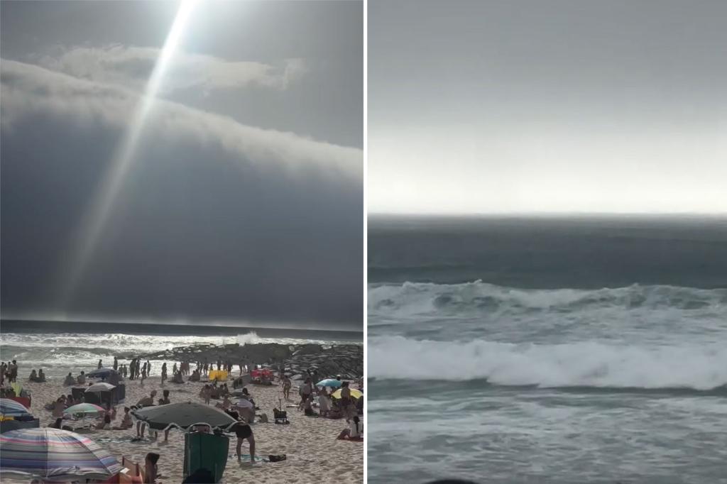
On a sweltering Sunday in Portugal, beachgoers at Praia de Buarcos experienced an alarming sight: a massive ‘tsunami roll’ cloud formation approaching the shore. Temperatures soared above 107 degrees Fahrenheit, creating the perfect conditions for this rare meteorological event. The cloud, dark and ominous, blocked out the sun and stirred up strong gusts of wind, causing many to fear an imminent tsunami. Viral videos captured people scrambling to gather their belongings and seek shelter as the cloud loomed closer.
The ‘tsunami roll’ stretched over 90 miles along the Portuguese coast, with sightings reported from Vila do Conde to Figueira da Foz. This extensive coverage made it one of the most significant roll cloud events in recent memory. Local outlets highlighted the awe and fear experienced by those who witnessed the phenomenon. Despite the initial panic, authorities clarified that it was a weather event and not a true tsunami. However, the incident served as a stark reminder of the impact of extreme weather and the importance of being prepared.</p
Nuno Pereira, a local resident, described the experience as feeling like a scene from a movie. ‘It was nuts to have experienced this rolling cloud in the north of Portugal,’ he said. The dramatic nature of the event quickly spread across social media, drawing international attention to the Portuguese coast. The combination of extreme heat and the sudden appearance of the roll cloud created a memorable and somewhat frightening experience for everyone involved.
‘Felt like a tsunami out of a movie!’ said one beachgoer.
The Science Behind the ‘Tsunami Roll’
The formation of the ‘tsunami roll’ in Portugal can be attributed to specific meteorological conditions. High temperatures, exceeding 107 degrees Fahrenheit, created a highly unstable atmosphere. This instability, combined with the arrival of a thunderstorm front pushing out cooler air, led to the rapid condensation of warm, humid air. As the cooler air met the warmer air, it trapped and started spinning horizontally, forming the characteristic tubular, wave-like cloud.
According to weather experts, this type of cloud formation, known as an arcus cloud, is relatively rare because it requires a precise combination of temperature, humidity, and wind conditions. The low-level clouds are typically associated with approaching thunderstorms, and their appearance can indicate the potential for severe weather. The spinning motion of the cloud is due to the differential wind shear, where winds at different altitudes blow at different speeds, further contributing to the rolling effect.
The National Weather Service explains that these clouds often form when a thunderstorm’s outflow boundary interacts with the surrounding environment. The cooler, denser air from the storm pushes under the warmer, less dense air, lifting it and causing it to condense. This process creates the dramatic cloud formations seen in Portugal. Understanding these atmospheric dynamics is crucial for predicting and preparing for similar weather events in the future.
‘The ominous clouds are typically formed when a thunderstorm front pushes out cooler air, causing the warm, humid air to condense into a cloud that can get ‘trapped’ and start to spin horizontally,’ explains a meteorologist.
Immediate Reactions of Beachgoers
The sudden appearance of the ‘tsunami roll’ over Praia de Buarcos triggered immediate reactions of awe and panic among beachgoers. Many, fearing an impending tsunami, scrambled to gather their belongings and move to higher ground. Videos circulating on social media showed people running from the beach as the dark cloud loomed closer, blocking out the sun and creating an eerie atmosphere. The sense of urgency was palpable, as families and individuals alike sought safety from what appeared to be a natural disaster.
Despite the initial fear, some beachgoers were also captivated by the spectacle. Many paused to record the event, capturing stunning footage of the approaching cloud formation. These videos quickly went viral, drawing attention to the rare weather phenomenon and sparking conversations about climate change and extreme weather events. The mix of fear and fascination highlights the complex relationship people have with nature, especially when confronted with its raw power.
Local authorities played a crucial role in calming the situation, clarifying that the event was a weather phenomenon and not a tsunami. This quick response helped to alleviate panic and prevent any potential stampedes or accidents. The incident underscores the importance of clear communication and preparedness in coastal areas, where the risk of natural disasters is ever-present.
‘It was nuts to have experienced this rolling cloud in the north of Portugal. Felt like a tsunami out of a movie!’ said one witness, capturing the sentiment of many.
Similar ‘Tsunami Roll’ Events Around the World
While the ‘tsunami roll’ in Portugal was a notable event, similar cloud formations have been observed in other parts of the world. These occurrences highlight the global nature of certain weather phenomena and the conditions that favor their development. One well-known location for roll clouds is Morning Glory cloud in Australia, which is a spectacular cloud formation that appears regularly over the Gulf of Carpentaria. These clouds can stretch for up to 1,000 kilometers and travel at speeds of up to 60 kilometers per hour.
In the United States, roll clouds have been observed in association with strong thunderstorms and cold fronts. Coastal regions, in particular, are prone to these events due to the interaction between land and sea breezes. Similar to the Portugal incident, these events often cause alarm, with people mistaking the clouds for approaching tsunamis or other hazards. The key difference is that ‘Tsunami Rolls’ or arcus clouds are produced by atmospheric conditions rather than tectonic activity.
These events serve as reminders of the importance of weather education and preparedness. Understanding the science behind these phenomena can help reduce panic and ensure appropriate responses. By studying past occurrences, meteorologists can improve their ability to predict and warn the public about potential roll cloud events, mitigating their impact and promoting coastal safety.
‘The Portuguese beach was primed to experience the phenomenon after its temperatures hit more than 107 degrees Sunday, with heavy rain, thunderstorms and even hail following the roll cloud,’ reports a local news outlet.
Implications for Coastal Safety and Tourism
The ‘tsunami roll’ incident in Portugal has significant implications for coastal safety and tourism. The event underscores the need for better public education about weather phenomena and the importance of heeding weather warnings. Coastal communities should implement clear communication strategies to inform residents and tourists about potential hazards and appropriate responses. This includes utilizing social media, local news outlets, and public announcement systems to disseminate information quickly and effectively.
For the tourism industry, such events can pose both challenges and opportunities. While the initial panic may deter some tourists, the dramatic nature of the phenomenon can also attract visitors interested in witnessing unique weather events. It is crucial for tourism operators to balance safety concerns with the potential for attracting weather enthusiasts. This can be achieved by providing accurate information, ensuring safety measures are in place, and promoting responsible tourism practices.
Furthermore, coastal regions should invest in infrastructure that enhances safety and resilience. This includes developing evacuation plans, improving early warning systems, and constructing shelters that can withstand extreme weather conditions. By taking proactive measures, coastal communities can mitigate the impact of future events and protect both residents and tourists.
‘Every morning, the offers a deep dive into the headlines with the Post’s signature mix of politics, business, pop culture, true crime and everything in between,’ emphasizes the importance of staying informed.
Conclusion: Key Takeaways from Portugal’s ‘Tsunami Roll’
The ‘tsunami roll’ event in Portugal serves as a compelling reminder of the power and unpredictability of nature. This rare weather phenomenon, characterized by a massive, wave-like cloud formation, caused both awe and panic among beachgoers. Its formation, driven by specific meteorological conditions including extreme heat and the interaction of warm and cool air masses, underscores the intricate dynamics of our atmosphere.
Key takeaways from this event include the importance of public education about weather phenomena, the need for clear communication strategies in coastal communities, and the potential implications for tourism. By understanding the science behind these events and implementing proactive safety measures, we can mitigate their impact and ensure the well-being of residents and tourists alike. The Portugal incident highlights the necessity for continuous learning and adaptation in the face of a changing climate.
As FYM News, we remain committed to providing accurate, timely, and informative coverage of such events. By delving into the details of what happened in Portugal, we aim to promote greater awareness and preparedness, empowering our audience to make informed decisions and stay safe. The ‘tsunami roll’ may have been a fleeting spectacle, but its lessons are enduring.
In conclusion, the ‘tsunami roll’ incident in Portugal was a remarkable event that offered valuable insights into the interplay between weather, human response, and community preparedness. As we move forward, let us continue to learn from these experiences and strive to create safer, more resilient coastal communities.
Leave a Reply