As the July 4th weekend approaches, Floridians are keeping a close eye on the tropics. Repeated rounds of stormy weather off the Southeast coast pose more than just a threat to fireworks displays. There’s a significant chance that this weather pattern will develop into the next named storm of the hurricane season, potentially disrupting holiday plans and bringing heavy rainfall.
This article will delve into the details of the developing tropical system, its potential impact on Florida and the Southeast, and provide insights into how to stay safe during the holiday weekend. Stay informed about the miami weather forecast to ensure a safe and enjoyable celebration.
We’ll cover:
- The increased chances of a tropical storm forming
- The potential for flooding and dangerous conditions
- The areas most likely to be affected
- Safety tips for the holiday weekend
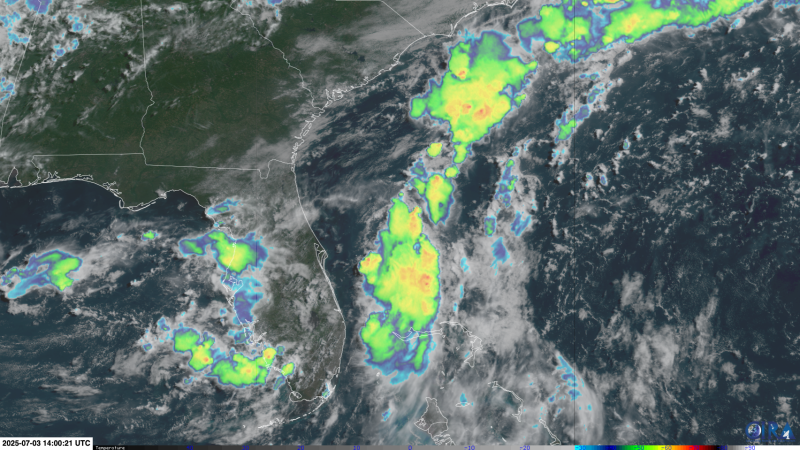
Tropical Storm Formation Likely
The National Hurricane Center (NHC) has increased the odds of a tropical system forming this weekend or early next week to 70%. If this cluster of storms strengthens, it will be named Chantal, becoming the third named storm of the Atlantic season. Regardless of whether it receives a name, the system is already delivering drenching rain, raising the flood risk in Florida.
The flood threat is particularly concerning, with millions of people expected to attend outdoor parties and fireworks displays. According to the Weather Prediction Center, portions of Florida and coastal Georgia could experience flash flooding through Friday. The threat will shift to the Carolina coast from Saturday into Sunday as the storms organize and move closer to land.
“Repeated rounds of stormy weather loitering off the Southeast coast could do more than just dampen fireworks celebrations in Florida this weekend – there’s a good chance it becomes hurricane season’s next named storm,” states the National Hurricane Center.
Flood Threat in Florida
The primary concern is the potential for significant rainfall leading to flash flooding. Some areas in Florida could receive up to 6 inches of rain by the end of the holiday weekend. Saturated soil increases the risk of flooding, especially in low-lying areas and urban centers. The excessive rain could also lead to transportation disruptions and property damage.
Residents and visitors should stay informed about local weather alerts and advisories. It is essential to avoid driving through flooded areas and to take precautions to protect property from potential water damage. The combination of heavy rain and holiday gatherings requires extra vigilance to ensure public safety.
Impact on the Southeast
The impact extends beyond Florida, with coastal Georgia and the Carolina coast also facing threats from this weather system. The storm could bring heavy rainfall, strong winds, and dangerous rip currents, affecting beaches and coastal communities. Residents in these areas should monitor weather updates and take necessary precautions to protect themselves and their property.
The Weather Prediction Center cautions that the Carolina coast could see over 3 inches of rain, leading to potential flash flooding and hazardous conditions. Boaters and swimmers should be aware of the risk of rough seas and rip currents. It is advisable to postpone water-related activities until the storm passes.
No Name, No Problem? Not Necessarily
Even if the system doesn’t develop into a named tropical storm, it can still cause significant issues. A well-defined center is not required to drag rich tropical moisture across the coastal Southeast, leading to localized downpours, dreary beach days, a risk of dangerous rip currents, and rough seas. These conditions can create hazardous situations for holiday travelers and outdoor enthusiasts.
The first two named storms of the season, Arlene and Barry, were weak and short-lived. However, this system poses a more significant flood threat to the United States due to its location and potential for heavy rainfall. Storms are more likely to form in the warm, shallow waters closer to land in July, making it a crucial time to stay prepared.
Fireworks, Not Floods, Beyond the Southeast
Outside of the Southeast, most of the country will experience ideal conditions for the July 4th weekend. The Northeast and West are expected to have calm, mostly clear skies from Friday onwards. The Southeast is likely to dry out by Tuesday, allowing for a return to more typical summer weather. The Plains and Upper Midwest may see strong to severe thunderstorms with damaging winds and hail through the weekend.
This divergence in weather conditions highlights the localized nature of the tropical system’s impact. While some regions prepare for potential flooding, others can look forward to celebrating Independence Day with clear skies and favorable weather.
Safety Tips for the Holiday Weekend
To ensure a safe and enjoyable July 4th weekend, consider the following safety tips:
- Stay informed about the latest miami weather forecasts and alerts.
- Avoid driving through flooded areas.
- Secure outdoor furniture and belongings.
- Be cautious of rip currents and rough seas if near the coast.
- Have a plan in case of evacuation.
- Monitor local news for updates on road closures and safety advisories.
By taking these precautions, you can minimize the risks associated with the potential tropical storm and enjoy a safe holiday weekend.
Conclusion
As the July 4th weekend approaches, a tropical storm threatens to disrupt celebrations in Florida and the Southeast. With increased chances of heavy rainfall and potential flooding, it is crucial to stay informed about the latest miami weather updates and take necessary safety precautions.
Whether you are planning outdoor activities or staying indoors, being prepared can make all the difference in ensuring a safe and enjoyable holiday weekend. Keep an eye on the tropics and celebrate responsibly.
Leave a Reply