The recent catastrophic flooding in Central Texas over the July Fourth weekend has left a trail of devastation, claiming over 100 lives and leaving more than 160 people missing. Satellite images provide a stark visual representation of the disaster, revealing the extent of the damage before and after the flood. This article delves into the impact of the flooding on key areas such as Camp Mystic and the Ingram Dam, highlighting the severity of the natural disaster.
The Guadalupe River surged rapidly due to heavy rainfall, particularly affecting Kerr County and its largest city, Kerrville. The satellite photos expose the scale of destruction, showing the impact on infrastructure, landscapes, and communities. By examining these images, we gain a deeper understanding of the challenges faced by residents and the ongoing emergency response efforts.
Through detailed analysis of satellite imagery, this article aims to provide a comprehensive overview of the Texas flooding, covering the impact on Camp Mystic, the condition of the Ingram Dam, and the widespread debris and damage. We will also explore the emergency response efforts captured in these images, shedding light on the scope of the disaster and the road to recovery.
Camp Mystic Before and After the Flood
Camp Mystic, a private Christian summer camp for girls located on the Guadalupe River banks, was severely affected by the flooding. Satellite images taken before and after the disaster reveal the extent of the damage. Before the flood, the camp was a lush, green area with well-maintained facilities. After the flood, the area is submerged, with buildings damaged and debris scattered throughout the landscape. At least 27 victims were reported at Camp Mystic.
The before-and-after satellite images vividly illustrate the impact of the flooding on Camp Mystic. The initial image shows a well-organized camp with clear recreational areas and structures. The subsequent image shows a completely altered landscape, with buildings partially underwater and debris accumulation. The comparison is shocking, highlighting the sheer force of the floodwaters and the destruction they caused.
These images underscore the tragic loss of life and the significant damage to infrastructure. The before-and-after comparison serves as a visual testament to the disaster’s impact on the camp. Maxar Technologies provided these satellite images, offering an aerial view that paints a clear picture of the devastation.
Ingram Dam’s Condition Post-Flood
The Ingram Dam, situated along the Guadalupe River in Ingram, Texas, also suffered damage from the severe flooding. Satellite imagery shows the area around the dam both before and after the event. The dam’s structural integrity and the surrounding landscape have been significantly affected, raising concerns about future stability and water management.
Before the flooding, the Ingram Dam appeared robust and well-maintained, with a healthy river flow. Post-flood images reveal visible damage to the dam’s structure and significant debris accumulation along the riverbanks. The alterations in the river’s course and the surrounding terrain are evident, showcasing the flood’s impact on the dam and the adjacent areas.
The satellite images provide a critical perspective on the dam’s condition. These visuals are essential for assessing the long-term implications of the flooding on water management and infrastructure. The post-flood scenario requires immediate attention to prevent further damage and ensure public safety, making these images valuable for planning and response efforts.
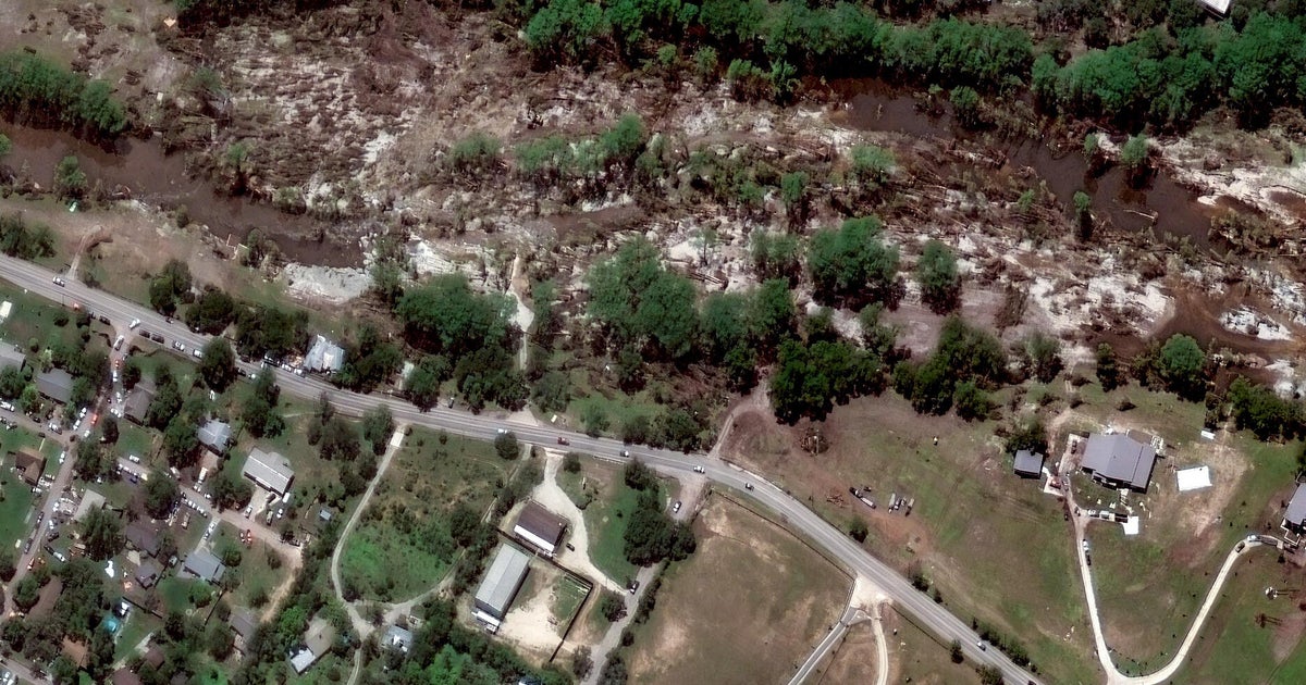
Downed Trees Along the Guadalupe River
The force of the flooding along the Guadalupe River resulted in widespread tree damage. Satellite images taken before and after the flood reveal the extent of the destruction, with numerous trees uprooted and scattered along the riverbanks. These images show trees lining the Guadalupe River banks in Hunt, Texas on June 23, 2023 and after the flood on July 8, 2025.
Before the flood, the riverbanks were lined with dense, healthy trees, contributing to the area’s natural beauty. The post-flood images display a dramatically different scene, with downed trees littering the landscape. The altered appearance underscores the power of the floodwaters and the impact on the local ecosystem.
The downed trees not only represent environmental damage but also pose challenges for navigation and future flood management. The satellite images are crucial for identifying the most affected areas and planning effective cleanup and restoration strategies. These visual insights emphasize the severity of the flooding and its lasting impact on the natural environment.
Debris Left Behind After Flooding
After the floodwaters receded, significant debris was left behind, posing environmental and logistical challenges. Satellite images clearly show the extent of this debris along the Guadalupe River, providing a comprehensive view of the post-flood landscape. These images show part of the Guadalupe River in Hunt, Texas, captured in June 2023 and aerial view showing debris left behind after flooding receded in Hunt, Texas.
The accumulation of debris includes everything from tree branches and vegetation to building materials and household items. This widespread debris complicates rescue efforts and poses a threat to the health and safety of the affected communities. The satellite images offer a clear picture of the scale of the cleanup required and the resources needed to manage the waste effectively.
By analyzing these images, authorities can better allocate resources and develop strategies for debris removal and environmental restoration. The visual evidence of the debris highlights the long-term impact of the flooding and the importance of thorough cleanup efforts to prevent further environmental damage.
Emergency Response Vehicle Locations
Satellite imagery also captured the presence and deployment of emergency response vehicles in the aftermath of the flooding. These images show vehicles parked along the Guadalupe River in Hunt and Ingram, Texas, revealing the strategic positioning of rescue and aid teams. Understanding the locations of these vehicles provides insight into the scope and coordination of the emergency response efforts.
The presence of emergency vehicles in specific areas indicates where help is most needed and where rescue operations are concentrated. The images show response vehicles along Guadalupe River in Hunt and Ingram, Texas.
These images offer a valuable overview of the emergency response efforts. By visualizing the deployment of resources, authorities can better coordinate aid and ensure that assistance reaches those who need it most. The satellite images underscore the importance of a well-organized and rapid response in the face of such a devastating natural disaster.
Conclusion: Understanding the Scope of the Texas Flooding
The satellite photos provide a comprehensive view of the devastation caused by the Texas flooding over the July Fourth weekend. These images highlight the significant impact on Camp Mystic, the Ingram Dam, and the widespread damage along the Guadalupe River. With over 100 lives lost and more than 160 people still missing, the scale of the disaster is immense, requiring extensive and coordinated emergency response efforts.
The satellite imagery underscores the importance of preparedness and effective flood management strategies. By visualizing the extent of the damage, authorities and communities can better plan for future events and mitigate the impact of severe weather. The lessons learned from this disaster can inform policies and practices aimed at protecting lives and infrastructure in flood-prone areas.
Ultimately, the satellite photos serve as a powerful reminder of the destructive force of nature and the resilience of the human spirit. As Texas begins the long road to recovery, these images provide valuable insights and a call to action for improved disaster preparedness and community support. The combined efforts of emergency responders, government agencies, and local communities will be crucial in rebuilding and ensuring a safer future for all.
Leave a Reply