The central and eastern United States are bracing for a series of severe storms, bringing the risk of torrential downpours, flash flooding, and damaging wind gusts. With high humidity fueling these storms, it’s crucial to stay informed and prepared. This article examines the impending weather threats and highlights how WeatherBug can provide real-time updates and critical safety information. Understanding the potential impact of these storms and utilizing tools like WeatherBug can significantly enhance your preparedness and safety.
From the northern Plains to the Ohio Valley and into the mid-Atlantic, various regions face the brunt of these severe weather patterns. Key areas such as eastern Pennsylvania and parts of the Northeast are particularly vulnerable. Stay tuned as we delve into the specifics of these weather forecasts and how WeatherBug can help you navigate these turbulent conditions.
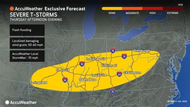
Thursday’s Severe Weather Outlook: Ohio Valley to Mid-Atlantic
Thursday’s forecast indicates a high risk of severe thunderstorms stretching from the Ohio Valley to the central Appalachians and potentially extending into the mid-Atlantic zone. The primary threats include damaging wind gusts and the possibility of flash flooding due to heavy downpours. Residents in these areas should be prepared for sporadic power outages and potential travel disruptions.
According to AccuWeather, “many areas from the Ohio Valley to the central Appalachians will be revisited by severe thunderstorms.” This heightened activity underscores the need for vigilance and proactive safety measures. WeatherBug’s real-time alerts can provide timely warnings, ensuring you’re always one step ahead of the storm.
Northeast at Risk: Tornado Potential and More
A separate zone of severe thunderstorms is expected in the Northeast, affecting areas from northwestern New England to parts of northwestern New Jersey and eastern Pennsylvania. The strongest storms may even produce tornadoes, especially from northeastern New York to northern Vermont and southern Quebec. Residents should closely monitor weather updates and be ready to take immediate action if a tornado warning is issued.
AccuWeather meteorologists caution, “It is possible that a couple of tornadoes are produced in the strongest storms on Thursday afternoon and evening, especially from northeastern New York to northern Vermont and part of southern Quebec.” WeatherBug’s advanced radar and lightning detection can provide critical information to help you stay safe during these dangerous conditions.
Friday’s Focus: Central and Southern Appalachians to the I-95 Mid-Atlantic
On Friday, the severe weather threat shifts to the central and southern Appalachians, extending towards the I-95 corridor in the mid-Atlantic region. Storms in this area are expected to bring locally damaging wind gusts and the potential for flash flooding. Areas from Delaware and Maryland to North Carolina are particularly at risk, highlighting the need for continued vigilance.
With storms capable of producing “locally damaging wind gusts, but with the potential for flash flooding,” it’s essential to have access to reliable weather information. WeatherBug offers detailed hourly forecasts and customizable alerts to keep you informed about changing weather conditions in your specific location.
Weekend Outlook: Plains and Midwest Reloading for More Storms
While the Northeast may experience a temporary reprieve from severe weather over the weekend, the atmosphere is likely to reload over portions of the Plains and Midwest. A new round of severe thunderstorms is forecast to erupt over parts of the northern Plains and the Upper Midwest during Friday night, indicating that the threat of severe weather is far from over.
As a southward push of dry air provides a brief respite in the Northeast, a new wave of storms is already brewing in the Plains and Midwest. Staying proactive with WeatherBug’s long-range forecasts can help you plan ahead and prepare for potential weather-related disruptions.
Harnessing WeatherBug for Safety and Preparedness
WeatherBug is more than just a weather app; it’s a comprehensive tool designed to keep you and your family safe during severe weather events. With features like real-time lightning detection, advanced radar, and customizable alerts, WeatherBug provides the information you need to make informed decisions and take timely action.
Whether you’re concerned about damaging wind gusts, flash flooding, or even tornadoes, WeatherBug offers the insights necessary to protect your home and loved ones. By providing hyperlocal weather alerts, you can stay one step ahead of the storm and minimize potential risks.
Conclusion: Staying Safe with Real-Time Weather Intelligence
The impending severe storms across the central and eastern United States pose significant risks, including flash flooding, damaging wind gusts, and even tornadoes. Staying informed and prepared is crucial for mitigating these risks and ensuring your safety. By leveraging the power of WeatherBug, you can access real-time weather updates, advanced radar, and customizable alerts to stay ahead of the storm.
As AccuWeather experts emphasize, monitoring dangerous weather risks is a 24/7 endeavor. With WeatherBug, you have a reliable partner in this effort, providing the tools and information you need to navigate severe weather events with confidence. Download WeatherBug today and take proactive steps to protect yourself and your family.
Leave a Reply