Get ready, Tampa! Southwest Florida is bracing for storms that will bring heavy rain and the potential for flooding. Gulf Coast News has declared both Saturday and Sunday as Weather Impact Days, urging residents to stay alert and prepared. With the majority of the Gulf Coast under a Level 1 risk of flash flooding, it’s crucial to understand the risks and take necessary precautions.
This article provides an in-depth look at the expected weather conditions, safety tips, and resources to help you navigate these potentially hazardous conditions. From understanding what an Impact Day means to knowing how to avoid floodwaters, we’ve got you covered. Stay tuned for the latest updates and ensure you’re ready for whatever Mother Nature throws our way.
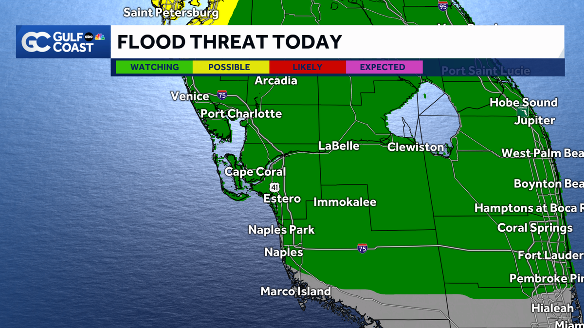
Understanding the Flood Risk in Tampa
The Gulf Coast is under a Level 1 risk for flash flooding, meaning that conditions are favorable for dangerous flooding. Tampa residents should be particularly cautious of standing water in low-lying areas and flood-prone regions. It’s essential to be aware of the potential for rapid water accumulation and take steps to protect yourself and your property.
According to the National Weather Service, it only takes 6 inches of swift-moving water to knock you off your feet. Furthermore, 12 inches of rushing water can wash away most vehicles. The advice is clear: ‘Turn around, don’t drown.’ Never attempt to cross floodwaters, whether on foot or in a car. Find an alternate route and wait for the water to recede.
Rainfall Forecast and Timing
Between 1 to 2.5 additional inches of rain are expected to fall through tomorrow evening. Expect torrential downpours to continue through the sunset hours. The heaviest rainfall is anticipated during the afternoon and early evening, so plan your activities accordingly and avoid unnecessary travel during these times.
While rain coverage may decrease overnight, showers and thunderstorms are expected to redevelop by mid-morning tomorrow. This means that the threat of heavy rain and flooding will persist throughout the weekend. Stay vigilant and monitor local weather forecasts for the latest updates.
What is a Gulf Coast Weather Impact Day?
A yellow triangle with an exclamation mark on weather forecasts indicates days when the weather is expected to disrupt normal routines. These Impact Days aren’t necessarily indicative of extreme conditions but can still cause significant problems, especially during peak travel times, holidays, or for outdoor activities.
For instance, dense morning fog or afternoon storms can slow down traffic and create slick roads, disrupting plans. The Impact Day symbol is also used for days with moderate cold or heat that may limit time spent outside. In short, it’s a signal to be extra cautious and prepared for potential weather-related disruptions.
Examples of Impact Day Weather
- Rain or storms that may limit outdoor activity, travel, or holiday plans
- Strong storms during a morning or evening commute
- Dense fog reducing visibility across major roads
- Moderate cold or summer heat limiting outdoor activity
- Burn bans caused by dry weather and strong wind gusts
These conditions, while not always severe, can still pose risks and inconvenience. Staying informed and taking precautions can help mitigate these impacts and ensure your safety.
Hurricane Season Preparedness
The Atlantic hurricane season runs from June 1 through Nov. 30. Now is the time to prepare. Make sure you have a hurricane preparedness kit that includes essential supplies such as water, non-perishable food, medication, and a first-aid kit. Review your evacuation plan and know where to go if an evacuation order is issued.
Follow Gulf Coast News online and on air for Southwest Florida’s Most Accurate weather forecast. Staying informed is your best defense against the unpredictable nature of hurricane season. Make sure you have access to reliable weather updates and heed any warnings or advisories issued by local authorities.
Staying Informed and Connected
Staying connected and informed is critical during severe weather events. Here are several resources to help you stay up-to-date:
- Live Interactive Radar: Track storms in real-time.
- Gulf Coast Weather Forecasts on TV or Online: Watch the latest updates.
- Gulf Coast News App: Stream news and weather alerts on your phone or tablet.
- Social Media: Follow the Gulf Coast Storm Team on social media for immediate updates.
By utilizing these resources, you can stay ahead of the storm and make informed decisions to protect yourself and your loved ones.
Conclusion: Stay Safe and Prepared
In conclusion, Tampa residents should brace themselves for a weekend of heavy rain and potential flooding. With Gulf Coast Weather Impact Days in effect, it’s essential to stay informed, take precautions, and avoid unnecessary risks. Remember, never enter floodwaters, and always heed the advice of local authorities.
By staying connected through local news, weather apps, and social media, you can remain one step ahead of the storm. Prepare your emergency kits, review your safety plans, and keep an eye on the forecast. Together, we can navigate these challenging weather conditions and ensure the safety and well-being of our community.
Leave a Reply